Skerretts Creek was the location for a water catchment in 1955 till the early 1960s. Water was piped out of the creek to serve the community’s needs.
Wainuiomata’s own supply
Skerretts Creek Water Catchment served as an alternative water source for Wainuiomata to avoid fees for utilising the Wellington Water supply from Morton Dam. This initiative commenced in the mid-1950s, but ceased operations in the early 1960s. During the late 1950s, the Hutt County Council assumed responsibility for Wainuiomata’s water supply.
From the mid-1950s to the early 1960s, Norman Willis through the Wainuiomata Development Company developed a housing subdivision in Homedale. This project encompassed areas along Hine Road, from the Poole Crescent intersection to its end, as well as Sunny Grove and Willis Grove, with the latter named after him. During this time, local water catchments starting in 1955, were initiated to harness water from streams behind Hair Street, but encountered problems due to turbid water. To address this, Norman Willis acting on behalf of the Hutt County Council, acquired 60 acres of Skerretts Creek in an area above Sunny Grove which he was compensated for later. Purchased from the Boys Brigade Organization, this land was intended to establish a reticulated water supply for this subdivision as well as the Wainuiomata Township.
The water catchment was constructed with two weirs, and included a secondary reservoir intended for major fires and other emergencies. The main reservoir had sufficient capacity to supply the whole of Wainui.
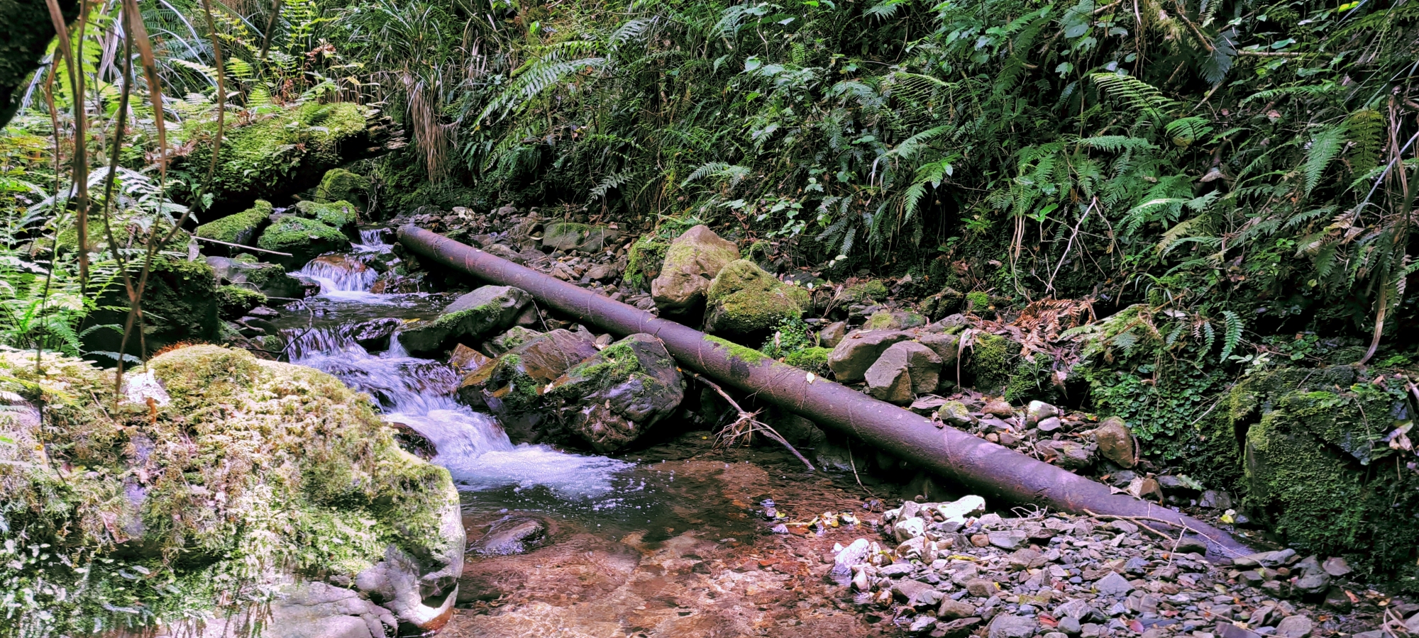
Alongside the catchment were four or five concrete storage tanks, as well as two steel pipes spanning the creek. In the 1960s, two additional tanks were installed along the Mount Crowther Track, which may have served as supplementary storage for fire protection and emergency use.
Willis was also compensated for upgrading his water main from 4 inches to 6 inches in diameter to meet the increased demand beyond his subdivision.
Problems
While water from the Skerrett’s Creek scheme was tested at the D.S.I.R. and found to be clear, with no evidence of life or debris, other tests at different times revealed water fleas, vegetable matter, and even small worms and a snail in the supply. Graded as D, the water was sourced from an upland surface catchment, where some contamination was considered normal due to animal activity above the intake.
The usual daily usage from the Skerrett’s Creek supply was about 250,000 gallons, but at times demand rose to 500,000 gallons or more. During these periods of increased usage, it was sometimes necessary to supplement the supply by switching to the Wellington water system.
Eventually, a decision was made to link with the WCC pipeline, granting residents access to water from Morton Dam. Additionally, the establishment of the Konini Reservoir ensured a reliable water source for Wainuiomata.
Decommissioning
 The scheme was decommissioned in the early 1960s and today, you can easily find eroding infrastructure in the form of broken pipes, old weirs, and vandalised water tanks nestled among the surrounding bush and in the creek bed. For example: between the top of Sunny Grove and before Skerritts Creek crosses the Whakanui Track, you can see a weir near the two remaining lower water tanks. There are also numerous broken sections of pipeline that run down the creek toward Sunny Grove.
Near the remaining water tanks by the creek are the remnants of a security fence. Some residents recall a ranger being stationed on site, although there is no firm evidence that the catchment area was actively managed in this way, despite being fenced off and restricted to the public.
Rangers were, however, employed within the Wainuiomata and Orongorongo Water Scheme, largely due to concerns about diseases such as typhoid being transmitted through the water supply. It is therefore plausible that this catchment may also have been patrolled at some stage.
One older Wainuiomata resident claimed that a ranger lived on site. If so, the dwelling may have been the Black House, an old hunters hut that was destroyed by fire in the 1970s.


DISCUSSION