I explored Sinclair Cemetery again and, just like 56 years ago, I wondered about those holly trees.
Back in the late 1960s and early 70s, the Sinclair Cemetery wasn’t known about. Us kids simply called it “The Bush” and it was directly behind our property. It was our go-to playground for epic games of cowboys and Indians or a good round of hide and seek. One day as a kid, while hiding in the undergrowth, I noticed something odd: the holly trees formed a near-perfect line, then abruptly turned 90 degrees and continued in another straight row. It struck me as strange, especially since I had never noticed that before due to the dense bush that had overtaken the site.
Decades later, the mystery was solved. That oddly tidy line of trees marked the boundary of what turned out to be one of the earliest burial grounds in Wainuiomata, the cemetery of the pioneering Sinclair family. Turns out, even back then, I was stumbling onto local history without even knowing about it.
 Today, I returned to check out a different patch of holly trees, this time forming the southern edge of the Hine Road Recreation Area, right next to the cemetery. If the holly trees marked the boundary of the cemetery, then what was the purpose of these other holly trees? Were they deliberately planted, or had they self-seeded from the original grove? I was keen to find out.
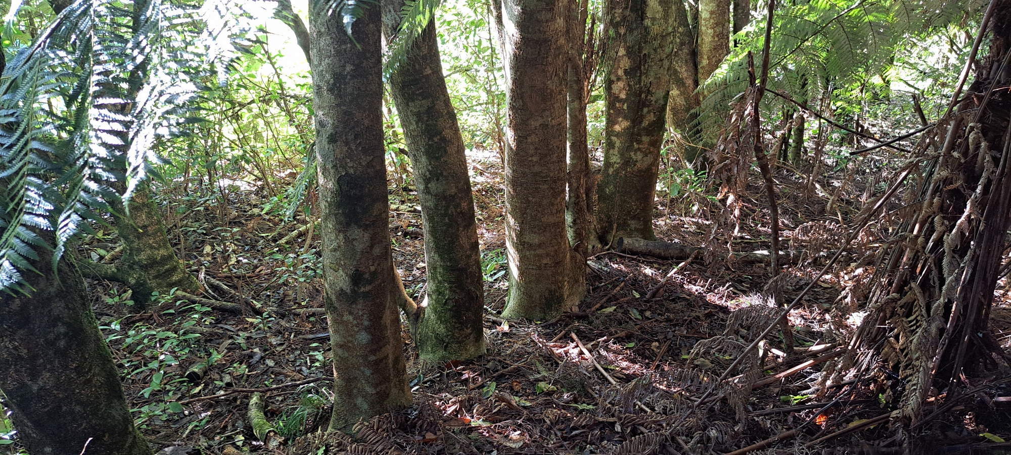 Starting near Top Pool Bridge, I followed the new track extension on the Gums Loop Walk toward the cemetery. Once the path ended, I bush-bashed the remaining short distance through to the cemetery. Sure enough, the holly trees in this section were old and substantial, almost as large as those in the cemetery. And just like those earlier trees, these too formed a line. That alone suggests intentional planting. To back that up, an old, faint track runs alongside them.
Could this have once been an elaborate entrance to the cemetery? Or perhaps part of the hypothesised Sinclair Track? I’ve long suspected that the older Whakanui Track just above might have been part of an original Sinclair route in this section, though now I’m not so sure as that track may have been cut later with the older track slightly below it.
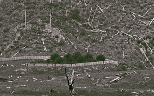
However, an old 1880s photo that clearly shows the cemetery does not show these holly trees I was looking at today, so they must have been planted later, probably to mark the perimeter of the farmland here. At one time, there were also holly trees growing in the centre of this farmland. Perhaps a later owner of this land planted them, such as John Wakeham, or maybe they were planted by Jack Cullen, who leased the land for a time.
 Anyway, I followed the faint old track toward the cemetery and continued to the western bank, heading down near the property where I grew up. There, I came across a large slip and what seemed to be a fallen holly tree, or at least a similarly sized species, sprawled down the slope. As far as I know, this is the first slip in that spot since houses were built there some 60 years ago.
Just south of the slip, I noticed a distinct cut in the bank leading down to a Sunny Grove property. It likely provided access up the slope, though I doubt it dates back to the Sinclair era. More likely, it was cut by a local resident as a shortcut from their property. Still, I wouldn’t entirely rule out an earlier origin. Interestingly, the clearest photo we have of the cemetery from the 1880s appears to show an entrance near this same location.
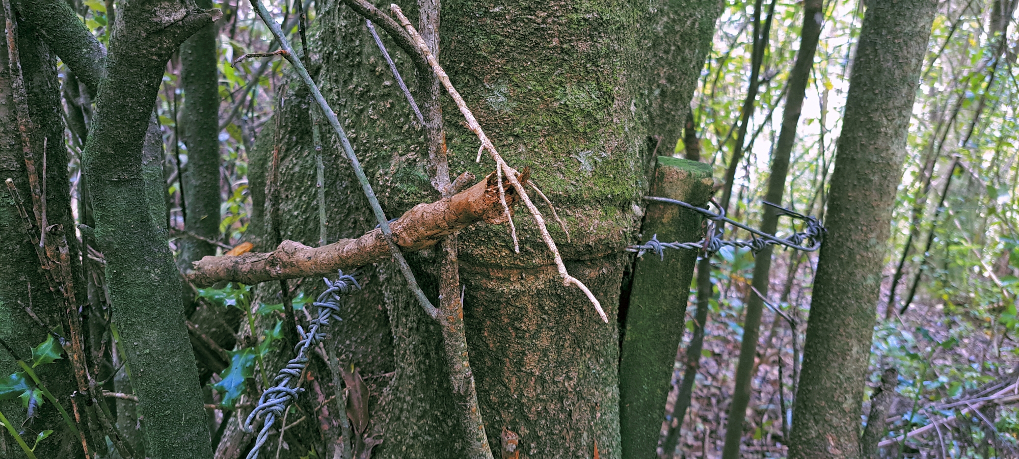 On a previous bush bash, I confirmed that the southern boundary of the cemetery is hidden in bush as a line of holly trees exist here, with old fence wire embedded in at least two of the trees. This suggests the line of trees I came across today is likely one continuous boundary of holly trees, but both rows planted at different times.
Taken together, it seems the cemetery’s perimeter was once marked out by holly trees, and that the southern line of holly outside the cemetery block was later extended part way toward Top Pool, above the recreation area and below the older Whakanui Track. The pattern in this area suggests that holly trees were deliberately planted to mark boundaries, perhaps a time-tested method today for discovering old property lines.
With time slipping away, I headed home, content in the thought that even a brief walk can uncover quiet traces of the past hidden in plain sight.


Excuse me ( ” Sir “) , in the above “bush tracks”
Story , WHOM IZ ” I “. Whom are you. ?
WE, many of us, climbed, plaid, walked, hiked, Swam all over that part of the Homedale valley. including Moores Valley.( a Moore , in my family tree ancestry. )
Txt , Email or call me anytime.
09 8469044 ~ Auckland , City of Sails, HD Motorcycles, and Damn good winter climate )
Hi Rob. My name is David Johnson. I use to live at Sunny Grove.