Significant Flooding Events That Have Impacted Wainuiomata’s Landscape
Wainuiomata has a long history of flooding, particularly during heavy rainstorms in February 2004 and earlier episodes. While historic maps and flood management plans have improved understanding, the suburb remains vulnerable due to its terrain and weather patterns.
February 2004 storm
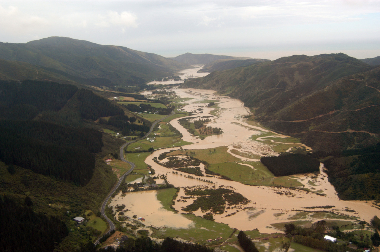
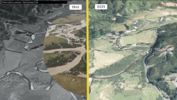 The February 2004 storm was one of the most significant flooding events to affect Wainuiomata in recent decades. Over the course of two days, from 14 to 16 February, a slow-moving weather system brought exceptionally heavy rain to the region. Rainfall totals reached up to 344 millimetres within 48 hours, overwhelming the Wainuiomata River and its tributaries. The volume and intensity of the rainfall caused widespread surface flooding, river overflows, and infrastructure damage throughout the valley.
The flooding affected many parts of the community. At least 26 homes and 15 businesses experienced flooding, with several properties suffering extensive damage. Road access was disrupted as culverts and bridges were damaged or blocked by debris. In some places, water treatment facilities and key utility services were temporarily compromised. The Wainuiomata River, running through the heart of the valley, rose rapidly and breached its banks, causing erosion along its margins and threatening built-up areas nearby.
Emergency services and council teams responded quickly, but the sheer scale of the storm meant that many residents were left dealing with the aftermath for weeks. In the years since, the February 2004 storm has been used as a benchmark for assessing local flood risk, with Greater Wellington Regional Council updating flood hazard maps and planning for improved resilience in the face of future extreme weather events. The storm served as a stark reminder of Wainuiomata’s vulnerability to flooding, particularly given its location within a steep and narrow valley catchment.
1985 flood
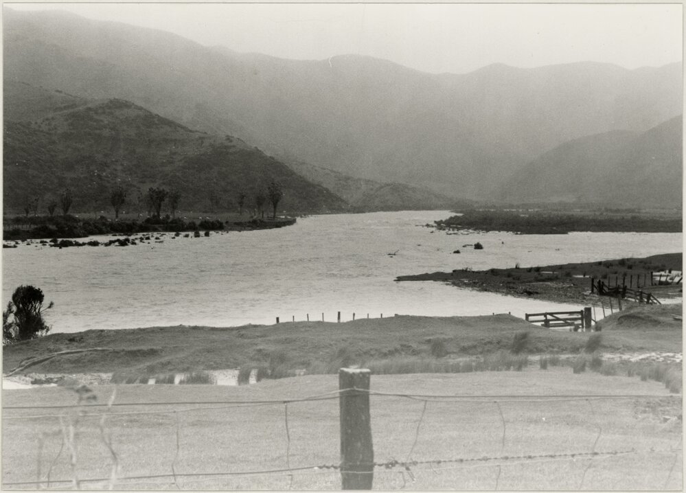
The 1985 weather event in Wainuiomata was a notable flood episode, remembered especially by long-time residents for its impact on farmland and rural infrastructure. While not as extensively documented as the 2004 storm, photographs and anecdotal accounts from the time show the Wainuiomata River in full spate, with water spilling over its banks and submerging low-lying areas, particularly in Moores Valley.
Heavy rainfall over a short period led to the river rising rapidly. The surrounding farmland, which was less developed than today, became waterlogged and impassable, with floodwaters spreading across paddocks and rural roads. Some bridges and culverts were damaged or temporarily unusable. In particular, the flat areas near the river’s bends proved especially prone to overflow.
The 1985 flood, while less severe in terms of damage compared to later events, served as a warning about the area’s hydrological vulnerability. It contributed to growing awareness in the late 20th century of the need for better flood planning and river management in Wainuiomata.
1976 flood
An intense storm hit Wellington and the Hutt Valley from 20–23 December 1976, bringing extremely heavy rainfall. Over 100 families in the Hutt Valley were evacuated, with widespread flooding and landslides.
1962 flood (Boxing Day Flood)
The Boxing Day flood of 1962 was a significant event that affected Wellington’s water supply, with direct consequences for the Wainuiomata catchment system. On 26 December 1962, an intense summer downpour caused heavy runoff from the surrounding hills, leading to high turbidity levels in the Wainuiomata River and its tributaries.
As the catchment collected a sudden influx of silt, debris, and muddy water, the Wainuiomata water treatment infrastructure was overwhelmed. The filtration system at the time could not cope with the sediment load, and raw water entering the reservoirs was discoloured and unsuitable for public supply. To avoid sending poor-quality water into the network, authorities had to shut down or restrict flows from the Wainuiomata intake temporarily.
This sudden reduction in available clean water put pressure on alternative supply sources, such as the Orongorongo pipeline and the Hutt River system. Wellington residents were asked to conserve water, and water tankers were placed on standby in case of prolonged disruptions.
In the aftermath, city council engineers increased focus on improving treatment capacity and enhancing catchment protection, including better erosion control, stream monitoring, and eventually upgrading infrastructure to handle poor raw water conditions more effectively. This included the introduction of chlorination in Wainuiomata’s water supply system.
1950 flood
On 15 July 1950, the Morton Dam’s water release caused loss of stock, damaged fences, and severe erosion downstream in the catchment. This shows how even controlled releases under flood-prone conditions can impact surrounding farmland and infrastructure.
1946–1948 floods
Regular flooding events across the Hutt Valley, with rainfall at Wainuiomata ranging from 4.2 to over 10 in, causing local flooding and transport disruption.
1944 flood
On 15 February 1944, over 10 in (≈254 mm) of rain in 24 hours around Wainuiomata, causing surface flooding though little structural damage
1904 flood
Heavy rainfall in October 1904 led to the water level at the Wainuiomata dam rising to the top of the wall and overtopping at the western corner. The overflow scoured the structure, deposited large logs, and blocked the downstream road and water pipes. Engineers described the overflow as “a sight that would compare very favourably with the Huka Falls”.
1883-84 floods
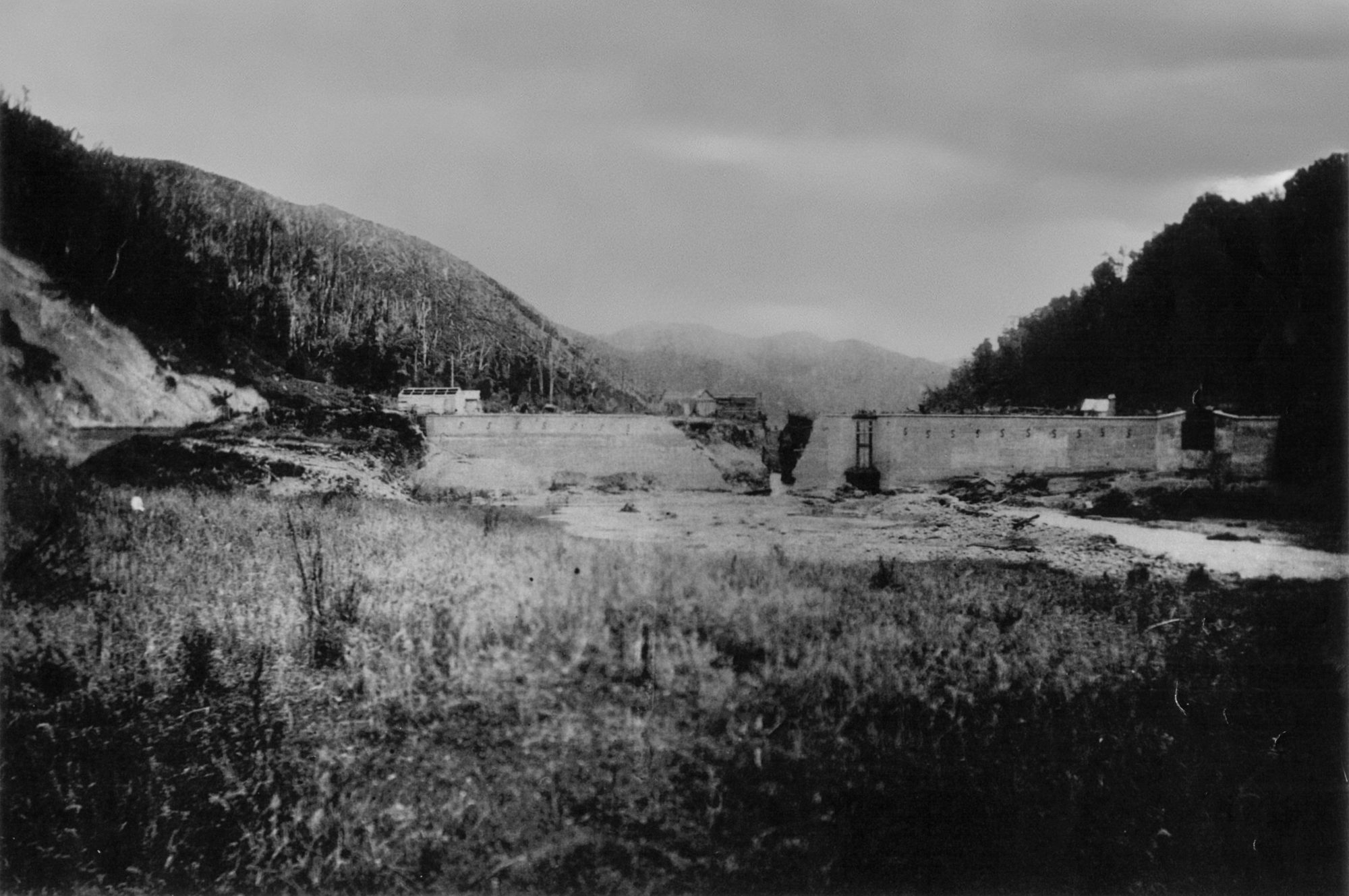 The original dam, part of Wellington’s water-supply scheme in Sinclair Valley, was nearing completion in late 1883. But from mid‑October onwards, heavy and persistent rain battered the region. On 19 October 1883, after a fortnight of continuous rain, floodwaters surged above the dam crest, washing away large sections of earth fill and creating a gap in the concrete face.
A subsequent flood in November 1883 caused additional deterioration. Then, in January 1884, another heavy storm overwhelmed the dam. Floodwaters overtopped the structure, sweeping away the temporary overflow flume and burying workmen’s huts near the site. Though the dam’s concrete core wall remained intact, the entire downstream boulder facing and backing fill were washed out—leaving behind a trench scoured into the rock and earth .
Council inspectors and engineers—including Wellington city councillors—assessed the damage in early 1884. They noted a large gap in the concrete face and deep scour holes at the base. This series of floods delayed the water-supply rollout to Wellington until about May 1884, when the dam was finally repaired.


DISCUSSION