The Naenae Tramway was used between 1906 and the 1910s to transport logs from Upper Moores Valley in Wainuiomata. A steam winch hauled the logs up to the ridgeline before lowering them down to the Naenae side of the hill (pictured), where a sawmill was located.
In the early 20th century, few Wellington residents were aware that bush-felling had been taking place so close to the city, just beyond Lower Hutt. It was commonly believed that the last of the millable forest had long since been cleared, leaving only isolated, inaccessible trees of poor quality. However, Messrs. Strand Bros. of Lower Hutt discovered that rugged, forested terrain near the city still contained some of the finest timber, comparable to that found in the most remote parts of the North Island. This operation, though challenging and hazardous, represented a profitable enterprise, balancing physical labour with keen business acumen. Despite the challenging terrain, the Strand brothers proved that valuable timber could still be harvested close to Wellington.
The Sawmill
Situated approximately four miles from Lower Hutt Railway Station, the Naenae mill was located at the foot of an 800-foot-high saddle. The sawmill once stood at what is now 249 Rata Street in Naenae, Hutt Valley, a site currently home to Wesleyhaven / Wesley Rata Village. The mill’s production averaged over 100,000 feet of timber each month.
Tramway Specs
The tramway stretched approximately 4.4 kilometers between the mill in Naenae and the head of Moores Valley in Wainuiomata. A telegraph line connected these locations to relay signals to the winding engine (steam winch), positioned at the top of the saddle. This engine, referred to as a 15-horsepower Luke Hauler, used steel cables to transport logs up and down the hill. Additional branch tramlines extended from the main trunk line into the forest to access new areas for deforestation. Both the main trunk and the branch lines were constructed with wooden rails.
Marketable Timber
The forest, covering 1,400 to 1,500 acres, proved to be denser and richer in marketable timber than the Strand brothers had initially anticipated. The main species being milled included rimu, white pine, birch, rātā, and mataī. The brothers faced scepticism when they proposed building a line up a nearly vertical hill to access the timber. Many had deemed the task impossible, but they persevered, extracting massive logs weighing up to four tons and measuring four to five feet in diameter.
Timber Usage
Timber from this once-overlooked forest reached the Hutt Valley by evening, transformed into boards ready for use. The majority of the timber served Petone and Upper and Lower Hutt areas, though some white pine was sent to Wellington. Over twenty men and nearly as many horses were employed in the bush and the Nainai and Whiteman’s Valley mills, which together produced 180,000 feet of timber monthly. As the timber was cleared, grass was sown for grazing, with cattle immediately feeding in areas that had been recently deforested.
Bush Fire
The Post reported on February 14, 1908, that a fire threatened to destroy the Strand Bros operation. The sawmill faced an imminent threat, but thanks to their dedicated team of employees, who worked tirelessly around the clock, they were able to save it. At one point, the danger was critical, but with the help of a nearby stream, workers used any available containers to fight the flames. A reporter later witnessed the intense struggle, noting how the fire came within feet of a sawdust pile before being extinguished. Mr. W. Strand himself battled the blaze and only left around 4 a.m. after securing the mill’s safety. Weeks earlier, a fire from a southern ridge had threatened the tram line, but Mr. Strand’s team stopped it just in time, preventing significant damage.
The Post earlier reported on February 12, 1908, that a grave threat had emerged from two approaching bush fires, one from the north and another from the south. Initially unnoticed, the fires gained momentum due to strong winds and converged near the mill and its tram-line. On Sunday, 15-20 men fought tirelessly to contain the flames, eventually saving the tram-line with minimal damage. To protect the mill, controlled fires were set, but vigilance was required as flare-ups occurred, including one threatening the sawdust heap on Thursday. By early the next morning, the immediate danger had passed, and Messrs. Strand Bros. reported minimal losses. While surrounding hills were scorched and blackened, and parts of the district remained ablaze, it was reassuring that the Wainui catchment area had so far been spared.
The Lost Forest
The Strand Brothers logged old-growth forest at the head of Moores Valley, as well as forests in the Hutt Valley, and Whitemans Valley. They were surprised by the abundance of high-quality timber in Moores Valley, which had been overlooked by other loggers. The valley’s forest was said to rival that of the more remote areas of the North Island, with species like rimu, white pine, birch, rātā, and mataī thriving there.
Had the Strand Brothers focused solely on their other locations, or if the bushfire had destroyed their tramline and sawmill, Wainuiomata might have been left with a preserved expanse of ancient forest on the hillsides and valley floor. In this scenario, the area could have developed into a significant scenic reserve. However, it’s also possible that the land would have eventually been sold and cleared by individual landowners, leading to deforestation at a later date.
Regardless of what might have been, the tramway and logging operations in Moores Valley remain a fascinating chapter in Wainuiomata’s history. Fortunately, Wainuiomata still retains pockets of old-growth forest, particularly around the water catchment area and up the hills towards the Remutaka Range.
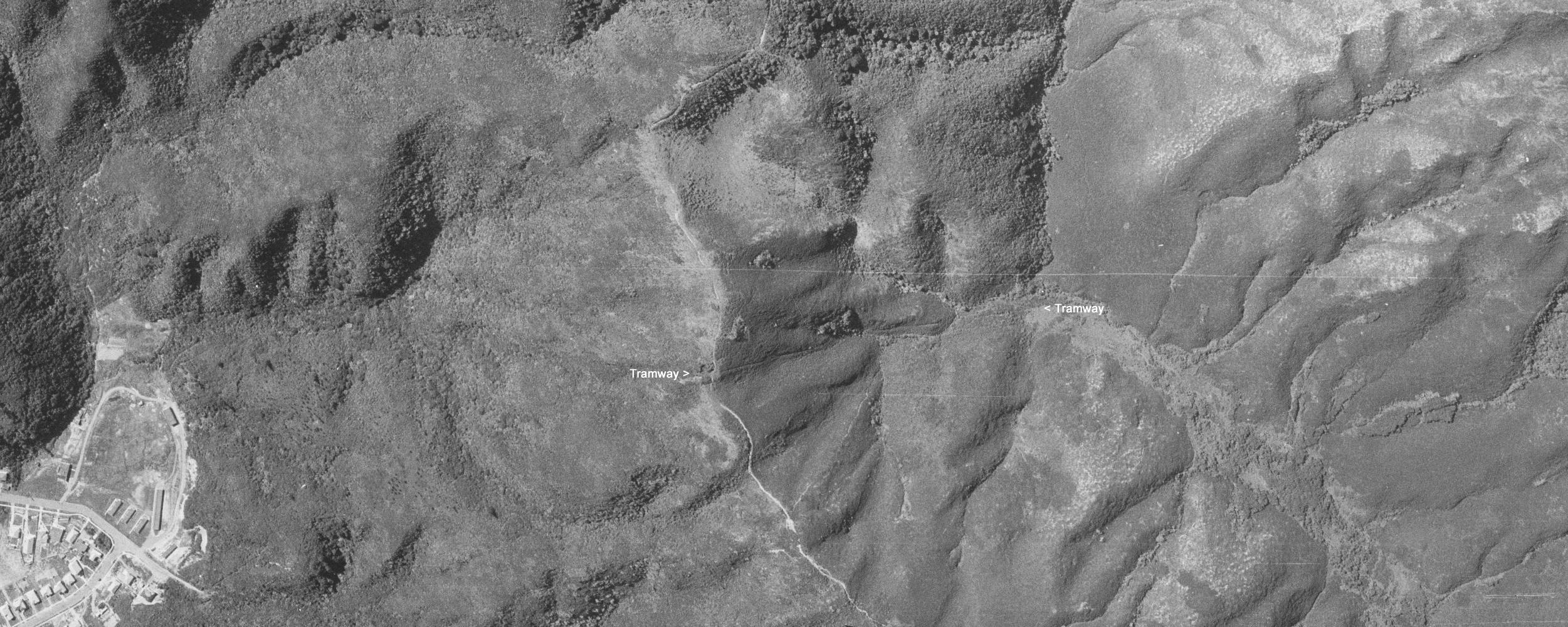
Aerial photo showing the tramway in Wainuiomata
Location of the Tramway in Naenae
 The tramway route starts near a grass field above Rata Street in Naenae. From there you head into the bush on the southside of a creek that runs along the Rata Street Loop Track at its northern entrance. You can also find the tramway track on the Rata Street Loop Track itself near the top as it crosses over the tramway track / chute. The tramway track’s location is also described in this Evening Post news article dated the 13th March 1907. Despite this information, the track is still hard to locate due to dense regenerating bush.
Location of the Tramway in Moores Valley
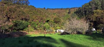
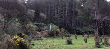
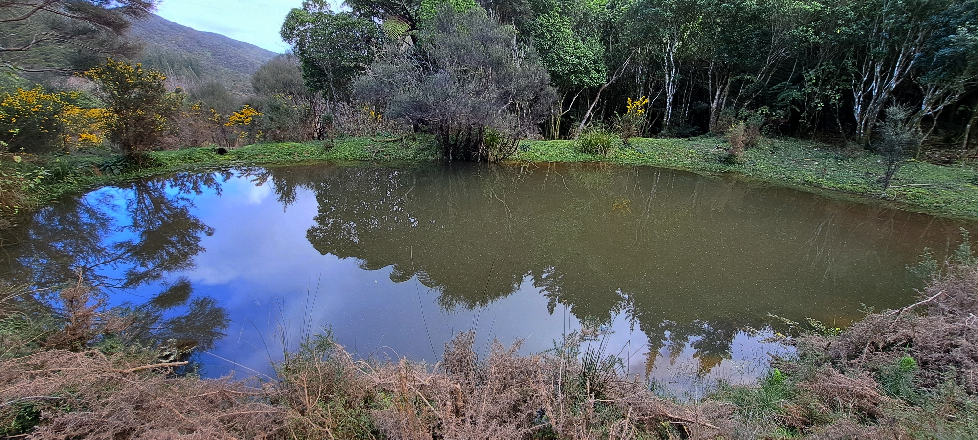 If you wish to start the tramway track in Moores Valley, the most obvious marker or direction to point the location out is an out of place bus stop sign that someone has planted into the ground in this isolated area. While that sign may not always be there, it is near a pond located on a flat area of grass and also near the Pylon Track, just before it crosses Wainuiomata Stream. So what is the rationale for identifying this as the location?
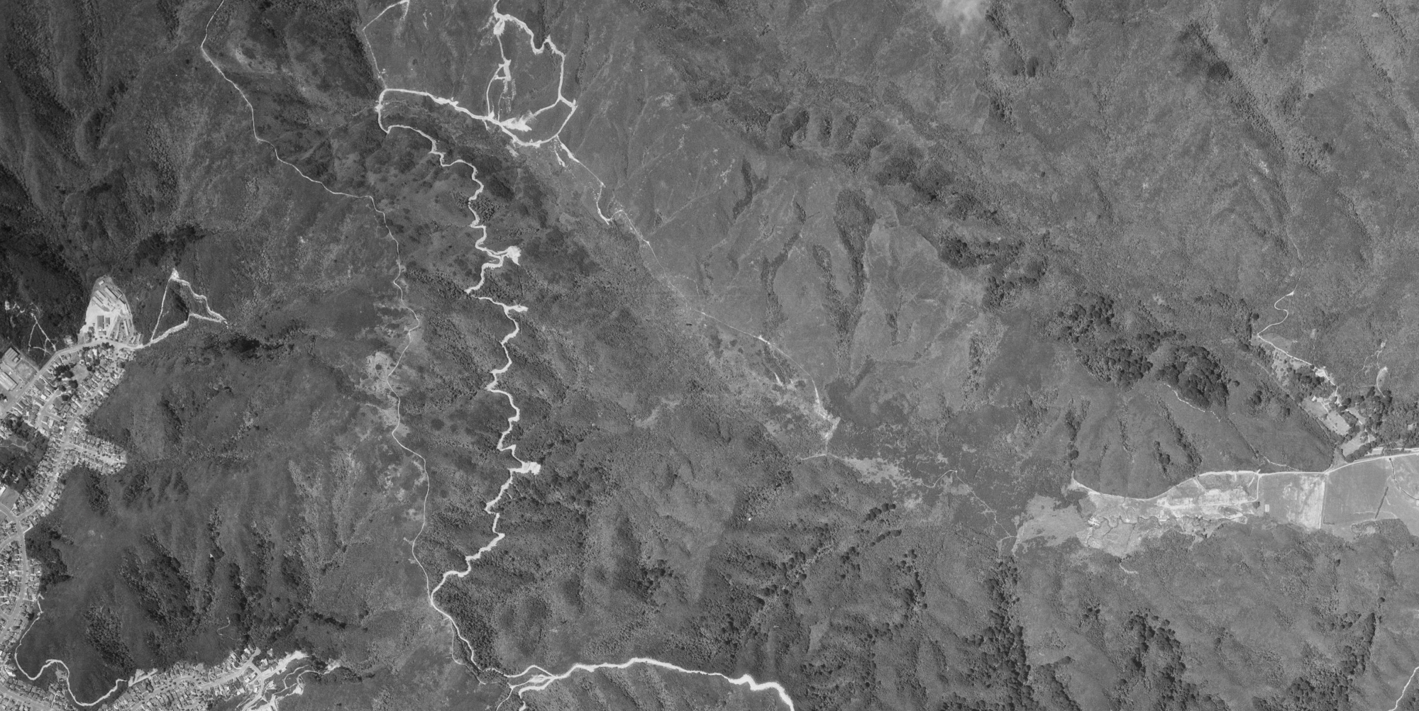
 The tramway line can be seen on a few aerial images taken from 1939 to 1974. See the gallery below. This provides the exact route. The problem is mapping that to Google Earth and the terrain today.
- On the ground in upper Moores Valley, there is a cut channel or chute in the landscape which agrees with the location of the tramway as seen in these old aerials. The Moores Valley terminus is located next to the convergence of three streams running down the hillside. Once you pass through this chute, you arrive at this flat grassy area.
- The three streams in question can be seen in these old aerials, thus mapping the approximate location of the tramway-chute near the terminus as the convergence of the streams are located next to the tramway-chute.
- One of these old aerials shows these streams and the freshly cut pylon track, which still exists today. The pylon track adds another layer of markers as this track is still there.
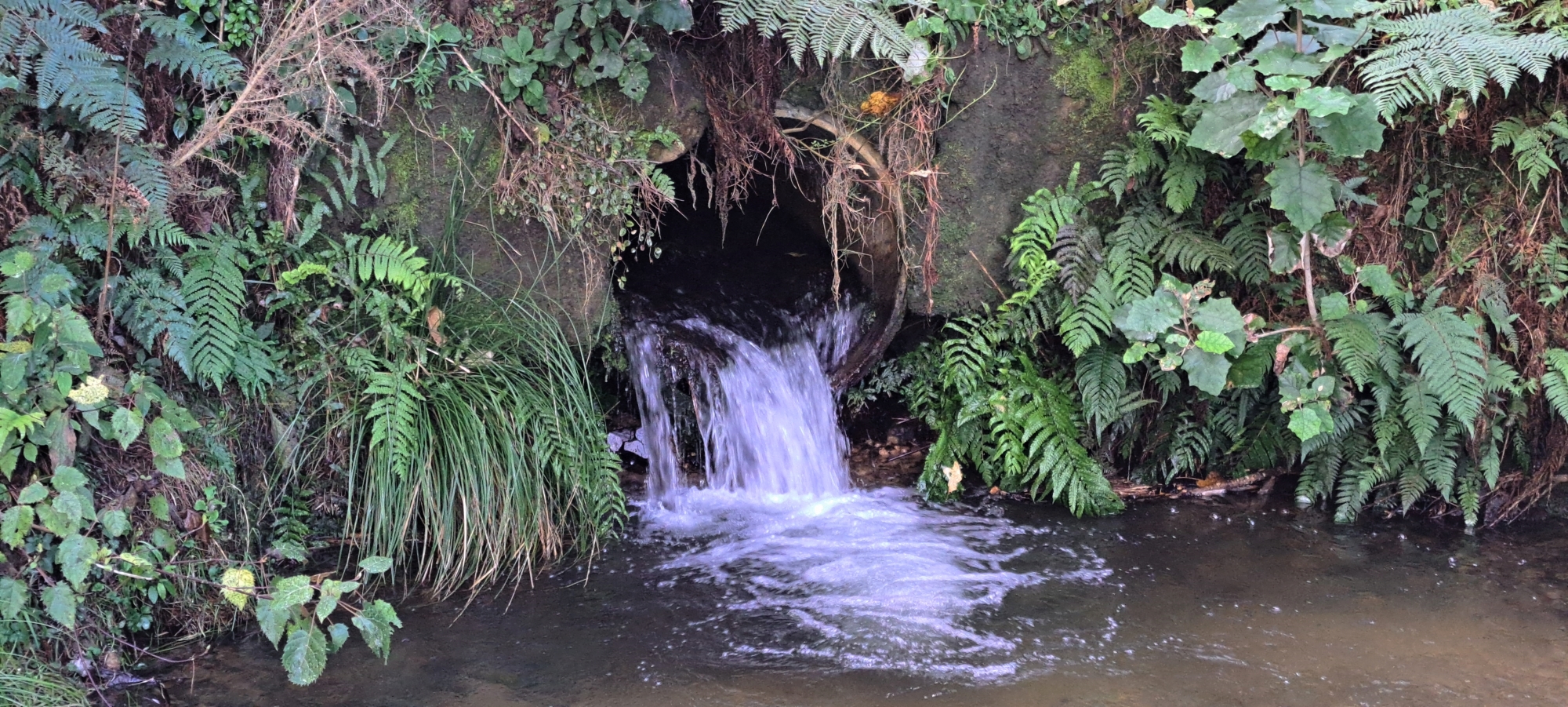
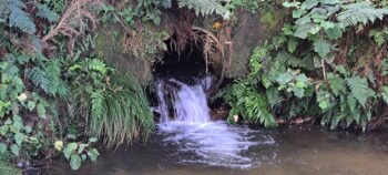 On the ground in Moores Valley, the pylon track curves around this flat area containing the pond and bus stop sign. The track then crosses the converged stream where this stream passes through a small pipe under the track and feeds into the Wainuiomata Stream. In the 1974 image, the pylon track has a bulldozed circle in this grass flat area where the pond is today and you can see the stream going under the track. Then comparing the 1957 aerial image that shows the tramway in Moores Valley, and comparing it to the 1974 image, you can overlay it quite easily in your mind where the tramway is in relation to the pylon track.
 The bus stop / pond area is flat and out in the open just outside the forest today. Surrounding land is steep and forested. The Wainuiomata Stream is also here. So the flat area is the most logical place where a tramway terminus would be located to avoid the three feeder streams and Wainuiomata Stream. It also avoids a steep hill that the pylon track climbs around. This flat area looked to be used for parking diggers and trucks and allow vehicles to turn around when constructing the pylon track. This bulge in the track can be seen in this 1974 black and white aerial image.

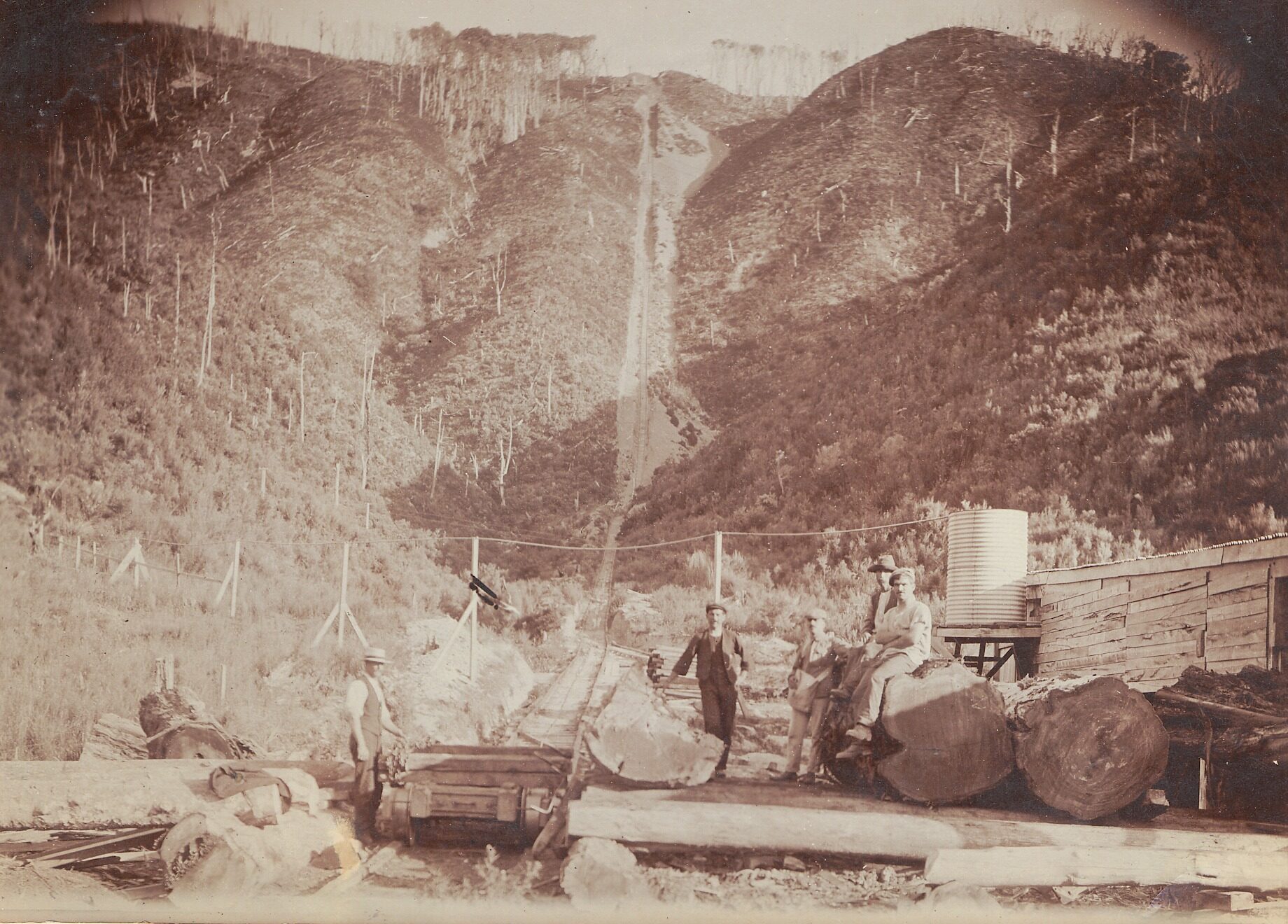
Is this a photo of the tramway in Moores Valley?
This photo is incorrectly labelled as Campbells in Karapoti circa 1908, taken around 20 years before Campbell’s Incline was constructed. Could this photo then be taken from the Wainuiomata side of the Naenae to Wainuiomata tramway? Let’s investigate.
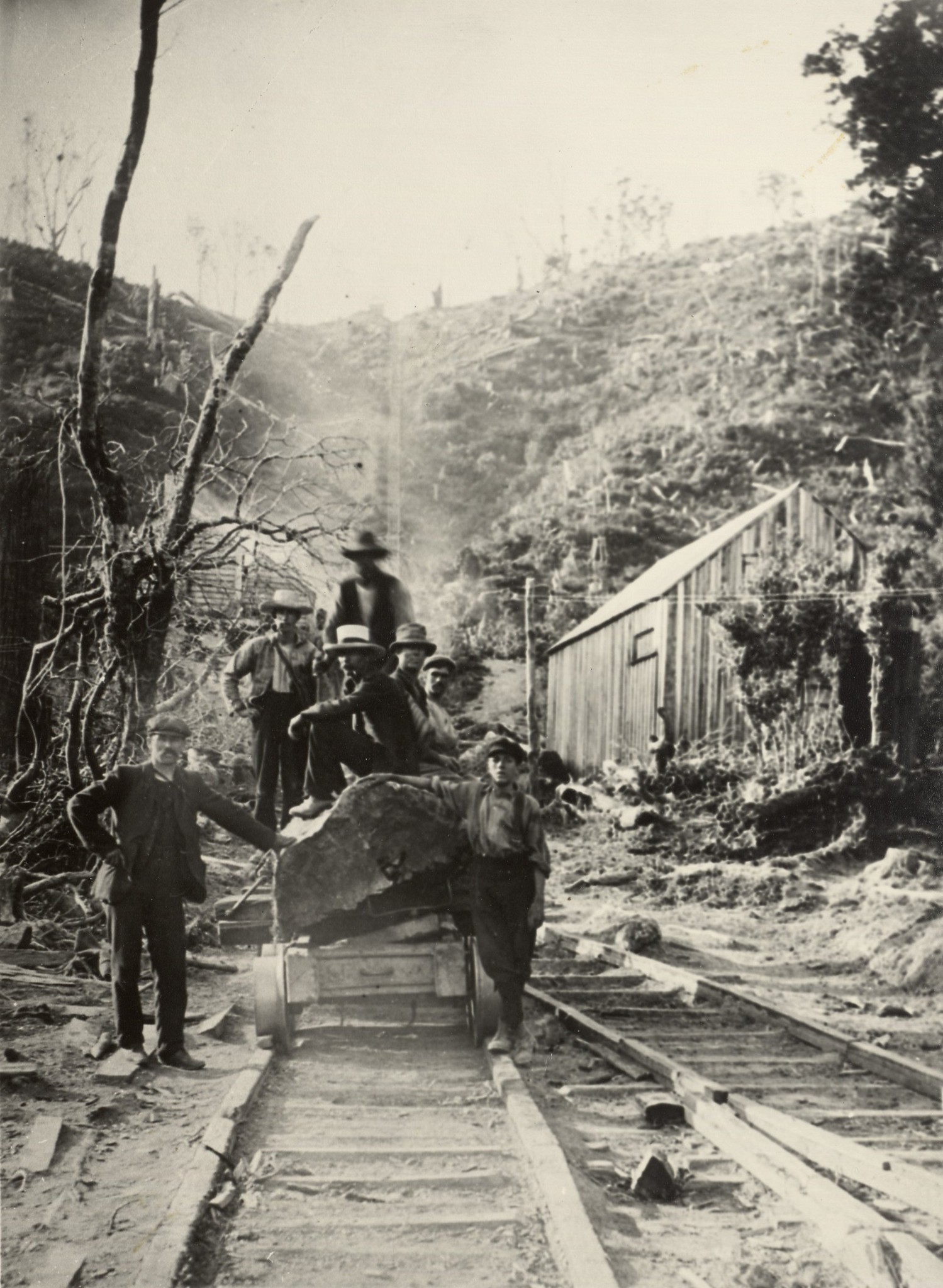
A 1907 newspaper article says:
“Over twenty men and nearly as many horses are kept constantly
employed in the bush, and at the Nainai’ mill and Whiteman’s Valley
mill, which, by the way, turns ‘ out 80,000 feet of timber monthly..
Telephones connect mill, hauling engine, and the log-hauling camp.”
There was a telephone at the log-hauling camp in Moores Valley, and the photo shows a telephone line. The photo also matches the topography of the Moores Valley side of the hill where the tramway was situated.
Both the Moores Valley side of the tramway and the photo have the following landscape features in common:
- The photo shows a natural low area (gully floor) where a creek likely flows just south and following the tramway track. This matches the landscape in Moores Valley where the tramway is located.
- In the photo, you can see another low point (gully) to the north that comes in at an angle where a creek likely flows. This matches the area too.
- The photo shows a natural spur near the bottom of the tramway track to the north. This matches Moores Valley as this is where the track is cut to pass through a spur near the bottom of the hill.
- Just after the spur in the photo is a building and there is a flat area of land covered in pine now in the equivalent location in Moores Valley. It seems sufficiently elevated there from a stream nearby. No evidence of a building has been found in that location yet. An old aerial photo in 1941 shows this area was once covered in grass which is logical if a building once stood there.
- Opposite the building, you can see another structure in the photo. In Moores Valley, the equivalent area is reasonably flat, but slightly more elevated agreeing with the photo.
- The news article uses the term log-hauling camp and there is a nice grassy field at the terminus of the old tramway in Moores Valley. Grass fields are often how people picture a camp.
Considering all the similarities, it’s seems quite feasible that this photo depicts the Wainuiomata end of the Naenae tramway. Feel free to leave a comment below if you have anything to add or correct.


