
Image sourced from LINZ Data Service and is licensed for reuse under the CC BY 4.0 licence.
The 1942 aerial photo above is the Sunny Grove valley with the original path of Skerretts Creek. The following 1948 plan of Sunny Grove matches the path of Skerretts Creek.
In the past, Skerretts Creek used to wind through both sides of the Sunny Grove valley. However, the creek’s path was altered by the land developer, aligning it exclusively behind the odd numbered houses (to the left in the photo and plan). This optimised the valley’s layout for housing purposes. The creek is visible in the center of the photo, depicted by the line of trees winding its way through the valley floor. Click the image to zoom in and navigate. You can also use your device’s zoom function to see more detail. On a phone or laptop trackpad, try the pinch gesture. On a PC, press CTRL and scroll your mouse wheel at the same time.
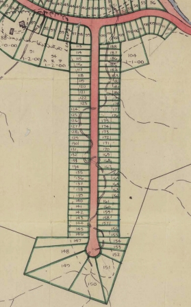
Skerretts Creek Original Path Map


)