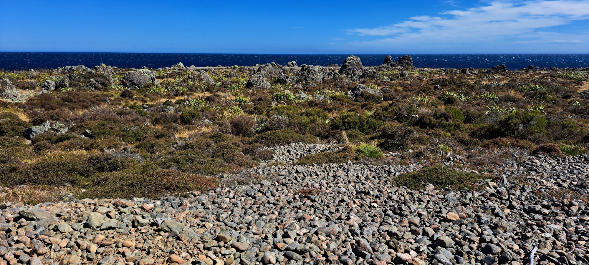
This gravel beach ridge marks the shoreline as it was approximately 2,300 years ago. Beyond this, there are two additional gravel beach ridges: one representing the shoreline prior to the 8.2 magnitude earthquake in 1855, and the other being the current coastline visible in the distance which has been there since the 1855 earthquake.
Gravel Beach Ridge
-
Lower Dam in 2022
, Photos, 0
Photo of the Old Dam in 2022. The reservoir was once thirty feet deep but was largely filled when...
-
Wainuiomata Valley View circa 1960
, Photos, 0
View of Wainuiomata Valley as seen from the summit of Wainuiomata Hill circa 1960. The suburb of Parkway and...
-
McDonalds in Wainuiomata
, News, Photos, 0
McDonald’s opened its restaurant in Wainuiomata, on April 13, 1999. Located on The Strand, it is across the...
-
Aerial Photo of Wainuiomata in 1966
, History, Photos, 0
This aerial photo, taken on 7 December 1966, captures Wainuiomata during a period of development. Arakura is shown under...
-
The History of Moores Valley Road
, History, Photos, 0
Moores Valley Road connects the oldest shopping area to a valley that epitomises the rural charm of Wainuiomata.
-
Concrete Well in 2023
, Photos, 0
Image depicting the concrete well captured in 2023. Initially built during 1881-1882, the well now remains concealed.
-
View from Spear Cut Track
, Photos, 0
View from Spear Cut Track of Reservoir Valley in Wainuiomata. Sunny Grove is hidden below the hill to the...
-
Morton Dam Spillway in 1965
, Photos, 0
Looking at the Morton Dam spillway in action in the year 1924. Morton Dam was once the main source...
SEARCH
RANDOM POST
TIMELINE
PAGES
- Wainuiomata
- History
- General History
- Notable People
- Historic Sites
- Hidden Sites
- Kittyhawk Plane Wreckage
- Wainuiomata Tunnel
- Waiwhetu Tunnel
- Black Creek Tunnel
- Colemans Tunnel
- Sinclair Tunnel
- Meter House
- Scour Pipe
- Earth Bridge
- Forgotten Power Generator Site
- Horse Powered Log Arch Cart
- Skerretts Creek Water Catchment
- Concrete Water Tanks
- Mount Crowther Track Water Tanks
- Scout / Pearson Hut
- Workers Huts
- The Black House
- Infrastructure
- Buildings
- Industries
- Waterworks
- Rivers
- Walks
- Reserves
- All Reserves & Parks
- Remutaka Forest Park
- Catchpool Valley
- Wainuiomata Regional Park
- Hine Road Recreation Area
- Harry Todd Recreation Area
- Richard Prouse Park
- Poole Crescent Reserve
- Rotary Park
- Wainuiomata Scenic Reserve
- Queen Street Reserve
- Bryan Heath Park
- Ngaturi Park
- Brookfield
- Camp Wainui
- Turakirae Head Scientific Reserve
- Puketahā Wildlife Sanctuary
- Wainuiomata Trees
- All Reserves & Parks
- About Us
WAINUIOMATA MUSEUM
