A track once connected the Sinclair sawmill with the Sinclair homestead of Moness.
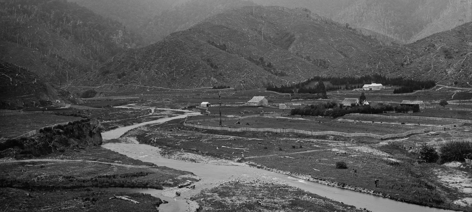
The above 1880s photograph was taken from The Rock on Moores Valley Road, a spot that still offers a great vantage point today. It captures what is now Richard Prouse Park and the surrounding area. In the photo, a track is visible near the bottom, running from left to right, with the Wainuiomata River cutting through it, likely at a ford crossing. On the northern / left side of the river, the track appears to ascend the plateau on a gentle sloping earth ramp, though decades of erosion sees this section as a steep bluff today. A boulder bank is also present at the river’s confluence, raising the possibility that the ramp section of the track seen in the photo may have been built using river boulders with fill on top. Perhaps this part of the track was later dismantled to form the boulder bank that is there today? The track appears to connect the homestead Moness with a plateau area on todays’ Whitcher Grove. So what was atop the plateau?
Around the 1960s, a Sinclair book was written that mentions this track as connecting Moness to a steam sawmill near the bluff, as well as to workers’ huts and Moores Valley. Another likely purpose for the track was its close connection to House Northbrook, built by John Mowlem in 1867 whose brothers in law were Duncan and John Sinclair.
By the time the photo was taken in the 1880s, logging in the area had ceased, and the steam sawmill was no longer in operation and is not visible in the photo. However, Smith’s Whare was probably there, as there is a photo of this hut taken in 1888, and it may have been one of the original workers’ huts during the logging era. Although Smith’s Whare isn’t visible in the 1880s photo, it is believed to be outside the frame to the left, closer to Moores Valley Road near the culvert, but situated above the bluff where the Wainuiomata Stream flows perpendicular to it before curving around it.
The name of the track remains unknown, and referring to it as the Mill to Moness Track is more of a descriptive label than an official name. It’s possible that after the mills closed, the track may have taken on a new name reflecting its purpose as a route connecting Moness with House Northbrook, Smith’s Whare, and Moores Valley.
A final note of interest for the time period is Duncan Sinclair may have been residing in House Northbrook with his family when the photo was taken. However, it’s also possible that the house was in the hands of the next owners: John and Mary Wakeham, with John being the grandson of Richard Prouse.
Today, the track remains intact on the northern side of the Wainuiomata River, though the ramp leading up to the plateau has disappeared. It’s possible that a boulder bank now present could have been constructed from the materials once used to form the ramp. Also, the remainder of the track that is still there is overgrown with blackberry and gorse bushes in sections, making it challenging to navigate.
For those eager to explore, there are two possible routes. The easier option is to cross the Wainuiomata River to access this small area. Alternatively, the more difficult route involves descending steeply from the culvert on Moores Valley Road and crossing the stream twice to bypass a deeper section where the stream meets the cliff.
In summary, it’s fascinating to see this old track in the photo, which was likely used by the Sinclair family and workers and may have even been part of the wooden tramway they built to transport logs to their mill. However, visiting the site today isn’t particularly rewarding, as there’s little to see, and any artefacts that might have been there have likely been washed away by floods over the years.


DISCUSSION