
Special thanks to Jeremy Foster for sourcing this document.
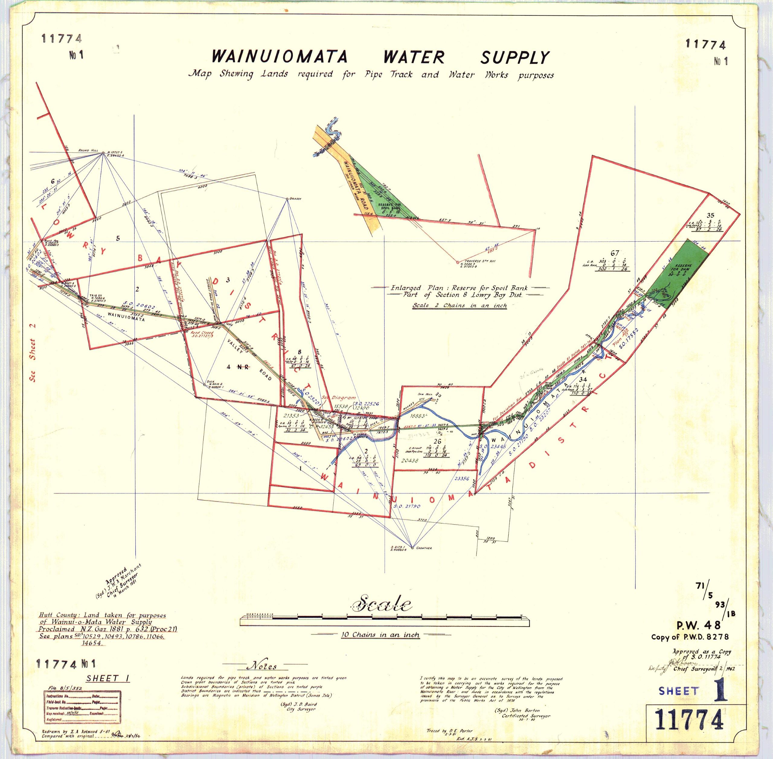
This 1881 plan shows the land proposed for acquisition for the development of the Wainuiomata water supply.
The area shaded in green marks the route of the pipe track, where the water race was to be constructed, along with other associated waterworks infrastructure and a designated reserve or catchment area. The main pipeline running through Wainuiomata is also shown on the plan.
Crown grant section boundaries are tinted pink, while private property boundaries are shown in purple. District boundaries are outlined with a dashed-and-dotted line.
The map was certified as accurate by John Barton in 1880 and traced by D.E. Porter on 2 March 1881. This is a certified copy made in 1962.
The 1881 plan outlines the proposed land to be acquired for the Wainuiomata water supply scheme. Several sections were identified for partial acquisition to enable the construction of waterworks infrastructure, including the dam, water race, and main pipeline:
- Section 35 was originally 120 acres, 3 roods, and 0 perches. Of this, 32 acres, 3 roods, and 14 perches were proposed for use in the construction of a dam and water race, leaving a balance of 87 acres, 2 roods, and 26 perches.
- Section 67 measured 303 acres, with 0 acres, 2 roods, and 14 perches (equivalent to about 0.5875 acres) proposed for the water race, leaving 302 acres, 1 rood, and 26 perches.
- A 30-acre reserve is marked out in green for the future construction and operation of a dam. This was typical in 19th-century New Zealand schemes, where additional land was set aside for catchment protection and operational space.
- Section 26 originally comprised 116 acres. The plan proposed 3 roods and 16 perches be used for the pipeline, reducing the remainder to 115 acres and 24 perches.
- Section 8 began with 68 acres. After the proposed deduction of 3 roods and 16 perches for the pipe track, 67 acres and 24 perches would remain.
- J. McIlvride’s holding was recorded as 25 acres. The plan indicates 1 rood and 32 perches (almost half an acre) would be used for the waterworks, leaving 24 acres, 2 roods, and 8 perches.
Note: New Zealand inherited the British imperial measurement system, where land was traditionally measured in Acres, Roods (¼ acre), & Perches (¹⁄₁₆₀ acre). These units appeared in Crown grants, survey plans, rates records, and titles throughout the colonial period. Metrication didn’t begin in NZ until the 1970s, so imperial units were universal in land records up to that point.
The water race and pipeline route on the plan are marked with sectional distances in feet along the outside of the green strip. Inside the strip, numbers appear that likely represent elevation in feet, not above sea level, but above a locally defined zero point used for design purposes. In the 19th century, surveyors often chose an arbitrary or convenient local reference point as their “datum” to simplify calculations, especially for gravity-fed systems.
In this plan, the zero point isn’t identified, but we can infer that it sits about 60 metres (approx 200 feet) above sea level. This is because the elevation values shown in feet align closely with modern sea-level elevations when converted, suggesting the numbers represent real elevation, just measured from a starting point around 60 metres up. While it’s common for the intake of a dam to serve as the base point, that doesn’t seem to be the case here, so the exact origin of the datum remains unknown at this point.
One theory for this zero point is the Wainuiomata River as it runs continuously through the valley, offering a reliable reference line with a naturally decreasing elevation, ideal for a gravity-fed system like a water race to follow. Using the riverbed (or a point along it) as “zero” would allow engineers to calculate gradients and fall over distance more easily.
Title
WAINUIOMATA WATER SUPPLY
Map Shewing Lands required for Pipe Track and Water Works purposes
S.O. 11774
No. 1
Sheet 1
Place names and features
- Wainuiomata
- Wainuiomata River
- Wainuiomata Road
- Sawmill
- Pipe Track
- Water Race
- Water Works
- Main pipeline
- Reserve
- Lowry Bay District
- Wainuiomata District
The plan is specifically catalogued as showing the Wainuiomata water supply lands and the sawmill on Section 26.
Sections and land shown
- Section 8
- Section 26
- Section 35
- Section 67
- J. McIlvride’s land
- 30-acre reserve
The areas shown on the plan include:
- Section 35: 120 acres, 3 roods, 0 perches
- Land required: 32 acres, 3 roods, 14 perches
- Balance: 87 acres, 2 roods, 26 perches
- Section 67: 303 acres
- Land required: 2 roods, 14 perches
- Balance: 302 acres, 1 rood, 26 perches
- Reserve: 30 acres
- Section 26: 116 acres
- Land required: 3 roods, 16 perches
- Balance: 115 acres, 24 perches
- Section 8: 68 acres
- Land required: 3 roods, 16 perches
- Balance: 67 acres, 24 perches
- J. McIlvride: 25 acres
- Land required: 1 rood, 32 perches
- Balance: 24 acres, 2 roods, 8 perches
Enlarged plan
The inset in the centre reads approximately:
Enlarged Plan: Reserve for [word unclear] Road
Part of Section 8 Lowry Bay Dist.
Scale 5 Chains to an inch
I would not use the road name without checking a higher-resolution original; it is the least clear significant wording on the scan.
Main scale
Scale
10 Chains to an inch
Explanatory notes
The notes explain the colouring and boundaries on the plan:
- Crown Grant section boundaries are coloured pink
- Private property boundaries are coloured purple
- District boundaries are shown by a dash-and-dot line
- The land required for the pipe track and associated waterworks is shown in green
The green areas therefore identify land proposed to be taken or reserved for the water-supply works, including the water race, pipeline route and reserve.
Survey and certification information
- John Barton
- Certified as accurate in 1880
- D. E. Porter
- Traced 2 March 1881
- Certified copy made in 1962
Bottom-left legal information
The smaller wording relates to:
- Hutt County
- Land taken for Water Works purposes
- Proclamation / Gazette references
- New Zealand Gazette, 1881
The individual proclamation and Gazette numbers are too faint in this copy for me to give them confidently.
Bottom-right references
- P.W.D. 8278
- Copy of P.W.D. 8278
- Sheet 1
- 11774
- Survey-office/archive reference numbers
Useful full description
Wainuiomata Water Supply – Map Shewing Lands required for Pipe Track and Water Works purposes – S.O. 11774, 1881.
This is an 1881 survey plan showing land proposed for acquisition for the Wainuiomata water-supply scheme, including the pipe track, water race, pipeline, waterworks reserve, the sawmill on Section 26 and portions of Sections 8, 26, 35 and 67.




