
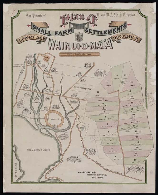
Historic survey plan of small farm settlements at Wainui-o-mata, showing land described as part of the old Lowry Bay District. The map helps explain why some early land records list parts of Wainuiomata under the Lowry Bay District name. As shown here, these sections lay inland behind Lowry Bay, reflecting how early surveyors used the bay as a reference point for the wider district.
This historic survey plan, titled “Plan of small farm settlements, Wainui-o-mata, Lowry Bay District”, shows how parts of early Wainuiomata were once described in land records as belonging to the Lowry Bay District. The map was surveyed by D. P. Davies, licensed surveyor, Wellington, and lays out a proposed small farm settlement with numbered sections, roads, streams, bush areas, and nearby landmarks.
The title is especially interesting because it links Wainui-o-mata with Lowry Bay District, even though today Wainuiomata and Lowry Bay are thought of as separate places. In this older context, “Lowry Bay District” was not a suburb name in the modern sense. It was a survey and land-title district, used to describe blocks of land before today’s suburban boundaries and council descriptions became familiar.
The map reflects a time when Wainuiomata was being promoted and divided into small rural holdings. Rather than showing a built-up township, it presents the valley as farmland, bush, waterways, and access routes. The inclusion of places such as Petone, Wellington Harbour, and the Lower Hutt Railway Station also shows how early access to Wainuiomata was understood in relation to the harbour side of the Hutt Valley.
For Wainuiomata history, this plan is useful because it helps explain why some old property records refer to parts of the valley as being in Lowry Bay District. The name does not mean the land was part of modern Lowry Bay, nor that the owners of Lowry Bay controlled all the land behind the bay. It reflects the way early surveyors organised and described land using wider district names and prominent coastal reference points.
Farm Lots Shown on the Map
The numbers 1-28 shown on the map represent individual farm lots, with the figures beneath each number recording the size of the property in acres, roods and perches. The map is part of the Fitzherbert family’s “Plan of Small Farm Settlements”, dating from the 1880s.
Several of the lot sizes can be confirmed from the map and supporting historical records:
- Lot 1 – 87 acres, 2 roods, 30 perches
- Lot 18 – 93 acres, 3 roods, 23 perches
- Lot 28 – 104 acres, 2 roods, 23 perches
These measurements help illustrate the substantial size of the original farm allotments before later subdivision and residential development transformed much of the area.




