
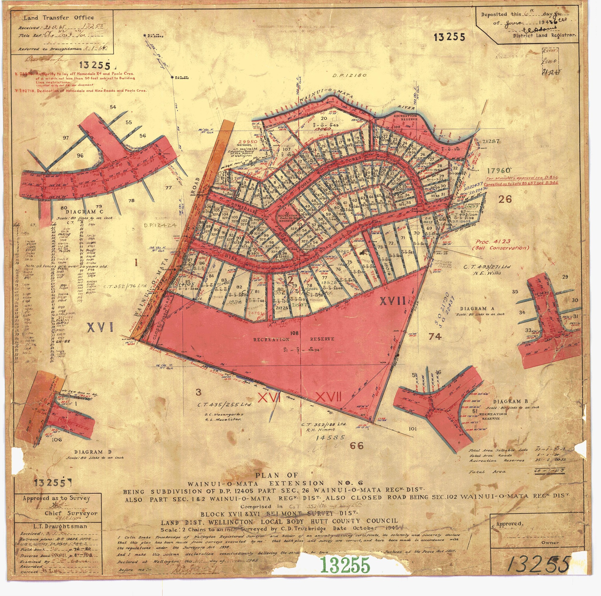
The surveyed subdivision plan from 1945 outlines the development of Hine Road, Homedale Road, and Poole Crescent.
In 1945, a surveyed subdivision plan was created for the construction of Hine & Homedale Road, as well as Poole Crescent. Notably, the plan highlights how big the sections backing onto the hill are compared to other sections. The block development encompasses approximately 100 sections, with some allocated sections on Homedale Road later removed to be instead used for Wainuiomata School. This undertaking marked the largest single development that WDC had embarked upon at that time.
The names Hine Rd (Edwin Hine) and Poole Crescent (Herbert Poole) were derived from the surnames of WDC investor members, a trend that continued with many other street names in the area. Homedale, initially a title or area name, was first applied in the valley to a road and area. By 1961, it had been officially adopted as the title for the village Post Office.
Originally named Main Road, the thoroughfare began at the base of the Wainuiomata hill Road in the valley. Following the intersection with Hine Road, it changed to Coast Road. In July 1963, the name Main Road was eliminated and replaced with Wainuiomata Road from the hill base to the Queen Street roundabout.
Special thanks to Carl Smith for supplying the image and information found in this article.
Top of plan
Land Transfer Office
Received: [handwritten – unclear]
Title No.: [handwritten – unclear]
Referred to Draughtsman: [handwritten – unclear]
13255
There is also a red annotation relating to the road widths. The clearly readable portion is:
Authority to lay off Homedale Rd and Poole Cres.
of a width not less than 50 feet subject to Building
line restrictions.
This corresponds with the 1945 Gazette authorisation allowing Homedale Road and Poole Crescent to be laid out at not less than 50 feet wide, subject to building-line restrictions. (NZLII)
A further red note appears to refer to:
Deviation of Homedale and Hine Roads and Poole Cres.
At the upper right:
13255
Deposited this 6th day of June 1946
[signature]
District Land Registrar.
That deposit date is also independently recorded for DP 13255. (NZ Pictures)
Bottom of plan
PLAN OF
WAINUI-O-MATA EXTENSION No. 6
BEING SUBDIVISION OF D.P. 12405 PART SEC. 26 WAINUI-O-MATA REGN. DIST.
ALSO PART SEC. 1 & 2 WAINUI-O-MATA REGN. DIST. ALSO CLOSED ROAD BEING SEC. 102 WAINUI-O-MATA REGN. DIST.
Comprised in C.T. 353/176
BLOCK XVI & XVII BELMONT SURVEY DIST.
LAND DIST. WELLINGTON LOCAL BODY HUTT COUNTY COUNCIL
Scale: 2 chains to an inch Surveyed by C.D. Troubridge Date October, 1945
The legal description is consistent with the official listing for DP 13255, which describes it as Wainuiomata Extension No. 6 and includes part Section 26, parts Sections 1 and 2, and the closed road forming Section 102. (NZ Pictures)
Below this is the surveyor’s statutory declaration. The wording appears to be:
I, C.D. Troubridge, of Wellington, Registered Surveyor and the holder of an annual practising certificate, do solemnly and sincerely declare that this plan has been made from surveys executed by me; that both plan and survey are correct, and have been made in accordance with the regulations under the Surveyors Act, 1938.
And I make this solemn declaration conscientiously believing the same to be true, and by virtue of the Justices of the Peace Act, 1927.
Declared at Wellington this [unclear] day of [unclear], 1945.
[signature]
Registered Surveyor
That wording was the prescribed form for Land Transfer survey plans under the 1940 Survey Regulations, so the faint portions of the plan are consistent with the standard declaration.
Bottom left box
13255
Approved as to Survey
[signature]
Chief Surveyor
L.T. Draughtsman
The remaining handwritten entries in this box appear to concern the date received, reference plans, field books, examination and recording of the plan, but they are too faint in this copy for me to transcribe confidently.
Bottom right box
Approved,
[signature / handwritten entry]




