
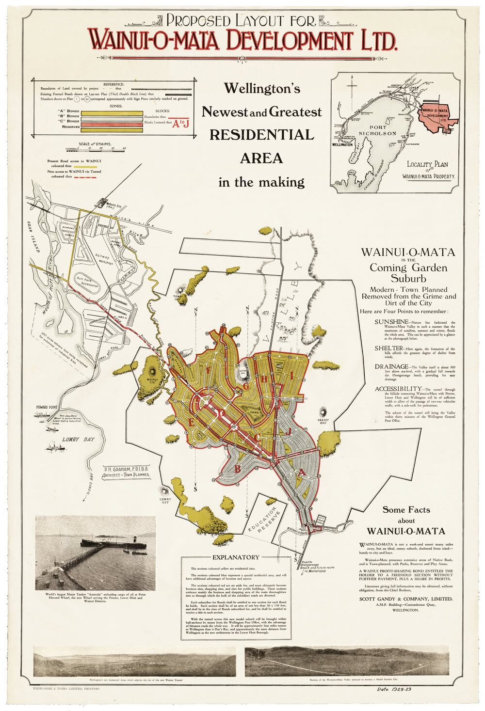
This 1928 plan offers a fascinating glimpse into an ambitious early vision for Wainuiomata as a major new residential suburb. It proposed a carefully planned “garden suburb” with residential, commercial and reserve areas, along with a road tunnel linking Wainuiomata more directly with the Hutt Valley and Wellington. Although much of the scheme was never realised in the form shown, the plan provides valuable insight into how developers imagined Wainuiomata’s future nearly a century ago.
PROPOSED LAYOUT FOR
WAINUI-O-MATA DEVELOPMENT LTD.
Wellington’s
Newest and Greatest
RESIDENTIAL
AREA
in the making
LOCALITY PLAN
WAINUI-O-MATA PROPERTY
WAINUI-O-MATA
IS THE
Coming Garden
Suburb
Modern – Town Planned
Removed from the Grime and
Dirt of the City
Here are Four Points to remember:
SUNSHINE – Nature has fashioned the Wainui-o-Mata Valley in such a manner that the maximum of sunshine, summer and winter, floods the whole area. This can be appreciated by a glance at the photograph below.
SHELTER – Here again, the formation of the hills affords the greater degree of shelter from winds.
DRAINAGE – The Valley itself is about 300 feet above sea-level, with a gradual fall towards the Orongorongo beach, providing for easy drainage.
ACCESSIBILITY – The tunnel through the hillside connecting Wainui-o-Mata with Petone, Lower Hutt and Wellington will be of sufficient width to allow of the passage of two-way vehicular traffic, with a side-walk for pedestrians.
The advent of the tunnel will bring the Valley within thirty minutes of the Wellington General Post Office.
EXPLANATORY
The sections coloured yellow are residential sites.
The sections coloured blue represent a special residential area, and will have additional advantages of location and aspect.
The sections coloured red are set aside for, and must ultimately become business sites, shopping sites, and sites for public buildings. These sections embrace mainly the business and shopping area of the main thoroughfare into or through which the bulk of the subsidiary roads are diverted.
Each subscriber for Bonds shall be entitled to one section for each Bond he holds. Such section shall be of an area of not less than 50 x 150 feet, and shall be in the class of Bonds subscribed for, and he shall be entitled to receive a title to such section.
With the tunnel access this new model suburb will be brought within half-an-hour by motor from the Wellington Post Office, with the advantage of bitumen roads the whole way. It will be approximately four miles nearer to Wellington than is Day’s Bay, and approximately the same distance from Wellington as the new settlements in the Lower Hutt Borough.
Some Facts about WAINUI-O-MATA
WAINUI-O-MATA is not a week-end resort many miles away, but an ideal, sunny suburb, sheltered from winds – handy to city and bays.
Wainui-o-Mata possesses extensive areas of Native Bush, and is Town-planned, with Parks, Reserves and Play Areas.
A WAINUI PROFIT-SHARING BOND ENTITLES THE HOLDER TO A FREEHOLD SECTION WITHOUT FURTHER PAYMENT, PLUS A SHARE IN PROFITS.
Literature giving full information may be obtained, without obligation, from the Chief Brokers,
SCOTT GANDY & COMPANY, LIMITED.
A.M.P. Building – Customhouse Quay,
WELLINGTON.
REFERENCE
Boundaries of Land covered by project – thus
Existing Formed Roads shown on Lay-out Plan (Thick Double Black Line) thus
Numbers shown on Plan 1 to 62 correspond approximately with Sign Posts similarly marked on ground.
ZONES:
“A” Bonds
“B” Bonds
“C” Bonds
Reserves
BLOCKS:
Boundaries thus
Blocks Lettered thus A to J
SCALE OF CHAINS
Present Road access to WAINUI coloured thus
New access to WAINUI via Tunnel coloured thus
Map labels
Among the clearer labels shown on the plan are:
Hutt River
Hutt Park Racecourse
Railway Workshops
Petone
Lower Hutt
Wellington
Port Nicholson
Eastbourne
Wainui-o-Mata Development Ltd.
Education Reserve
Town Hill
Grassy 840′
Lowry 1225′
The planner is identified as:
P. H. GRAHAM, F.R.I.B.A.
ARCHITECT – TOWN PLANNER
Photograph caption
World’s largest Motor Tanker “Australis” unloading cargo of oil at Point Howard Wharf, the new Wharf serving the Petone, Lower Hutt and Wainui Districts.
Bottom panorama captions
“Wellington’s new Industrial Area, which adjoins the site of the new Wainui Tunnel”
and
“Portion of the Wainui-o-Mata Valley destined to become a Model Garden City”
At the bottom:
WHITCOMBE & TOMBS LIMITED, PRINTERS
Handwritten:
Date 1928-29




)