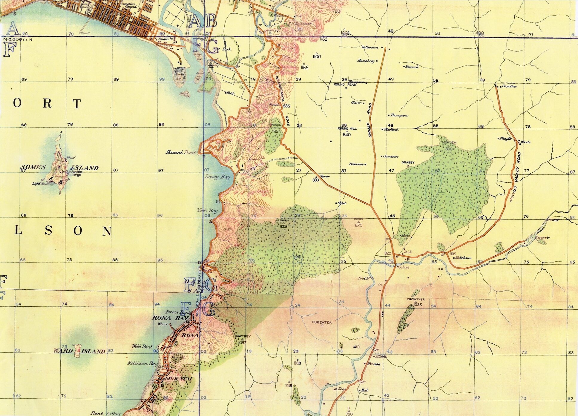
This 1900 survey map provides a detailed picture of Wainuiomata and the surrounding district at the beginning of the twentieth century. It shows roads, rivers, streams, hills, houses, farms, bush, bridges and other features, as well as the surnames of many of the settlers living in the valley at the time.
The map appears to be part of S.O. 14654, a topographical survey covering the Wainuiomata River and surrounding districts. The surviving survey fieldbook is particularly useful because it helps confirm some of the smaller names and features that are difficult to read on the map itself.
Harbour, islands and coastal places
The wider map extends beyond the Wainuiomata valley and includes a number of familiar coastal and harbour locations:
- Port Nicholson
- Somes Island
- Ward Island
- Howard Point
- Lowry Bay
- York Bay
- Rona Bay
- Rona
- Robinson Bay
- Muritai
- Point Arthur
These names help place Wainuiomata within the broader geography of Wellington Harbour and the eastern bays.
Roads and routes
Two important Wainuiomata roads are identified:
Swamp Road was the earlier name for what later became Fitzherbert Road.
The survey records a number of other routes and crossings through the valley, including:
- Bridle track
- Dray road
- Road on east side of river
- Ford
- River crossings
These features show how people moved through the valley before the modern road network developed.
Rivers, streams and water features
The map includes the main waterways of the district, including:
- Wainuiomata River
- Black Stream (Black Creek)
- Wainui-o-mata iti
- Gollan’s Stream
- Grace’s Stream
The associated survey notes also record old stream courses, drains, swampy ground and several smaller unnamed tributaries flowing into the Wainuiomata River.
These waterways were important features of the early valley landscape, influencing settlement, farming, roads and river crossings.
Hills, peaks and survey points
The map and associated survey records identify a number of hills, ridges and trig points:
- Round Peak
- Round Hill
- Crowther
- Dicks
- Lowry
- Grassy
- Mowlem
- Pukeatea
- Hawtry
- Middle Ridge
The survey field notes also provide elevations for several of these features:
- Crowther – 750 ft
- Round Hill – 640 ft
- Round Peak – 725 ft
- Middle Ridge No. 1 – 1230 ft
- Middle Ridge No. 2 – 1150 ft
Different figures appear elsewhere for some trig points, which may reflect different survey marks or observations.
Settlers and properties
One of the most interesting aspects of the map is the number of settlers’ surnames shown beside houses and properties.
The 1900 survey record includes the following names:
- Burrow
- Collier
- Dick
- Fitzherbert
- Glover
- Gustavasen
- Humphrey
- Jameson
- Oliver
- Patterson
- Peterson
- Prouse
- Stafford
- Thomson
- Wakeham
- Whitcher
- Woods
Several of these names appear beside more than one building.
The survey notes record:
- Four buildings associated with Peterson
- Three buildings associated with Jameson
- Two buildings associated with Stafford
- Four buildings associated with Thomson
- Two buildings associated with Woods
The spelling “Witcher” is how the name appears in the survey fieldbook register. It is connected with the Whitcher family, but the spelling recorded in the original survey material has been retained here.
Buildings and structures
A wide range of buildings and other structures are shown or referred to on the map and in the survey notes.
These include:
- Houses
- Homesteads
- Cottages
- Sheds
- Burrow’s Post Office
- Road cottage
- Bridges
- Footbridges
- Suspension bridge
- Stockyard
- Sheep yards
- Whare
- Reservoir
A number of individual buildings are plotted without names.
The presence of bridges, yards, cottages and farm buildings gives a useful impression of how settled and developed parts of the valley had become by 1900.
Vegetation and land use
The map also records the types of vegetation and land use found around Wainuiomata.
Labels and survey annotations include:
- Bush
- Birch bush
- Tawa bush
- Manuka
- Drained swamp
- Swampy ground
- Orchard
- 5 acres of bush
- 2 acres bush
- 3 acres of Tawa bush
These annotations show a landscape in transition. Large parts of the valley had already been cleared and converted to farmland, while significant areas of native bush still remained on the hills and in less accessible places.
The references to drained swamp and swampy ground also reflect the naturally wet character of parts of the Wainuiomata valley before extensive drainage and development.
Other features
A number of smaller features are also recorded:
- Prouse mark
- Cairn
- Totara
- Stump
- Island
Together with the roads, buildings and waterways, these smaller survey points helped the surveyors establish locations and bearings throughout the valley.
The 1900 survey
The contemporary fieldbook records that the survey was undertaken by H. Richardson from 16 July 1900.
The survey followed the Wainuiomata River and the surrounding valley, recording bearings to houses, roads, streams, ridges, trig points and other visible features.
S.O. 14654 is catalogued as a “Topographical Plan of part of Belmont, Rimutaka and Pencarrow Survey Districts”.
It covers the Wainuiomata River from its source towards the coast and records buildings, settlers’ surnames and many of the physical features of the district.
A snapshot of Wainuiomata in 1900
The map provides a valuable snapshot of Wainuiomata at a time when the valley was still largely rural.
Farms, homesteads, bush, streams, swamp, tracks and early roads are all shown together, along with the names of families who were living and working in the district.
It also captures a landscape that has since changed considerably. Some roads and place names remain familiar today, while others have disappeared or been renamed.
The map is therefore useful not only as a survey document, but also as a record of Wainuiomata’s early settlement, geography and changing landscape.