
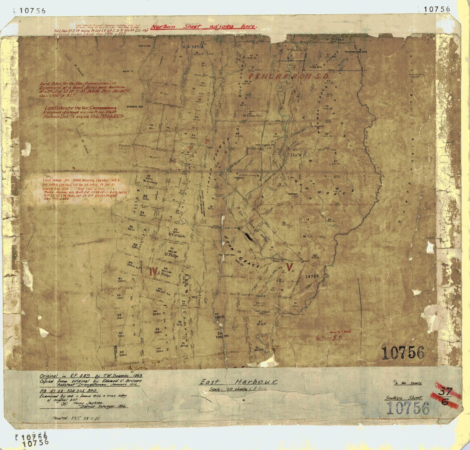
Special thanks to Jeremy Foster for sourcing the map.
This early survey map provides a fascinating view of the Coast Road area, western Wainuiomata hills and East Harbour area during the nineteenth century.
Alongside numbered rural sections and survey boundaries, the map records hills, ranges, bays, points, survey stations, district boundaries and the names of many early landowners. Some of the names remain familiar today, while others have disappeared from modern maps.
The map is also a useful reminder that nineteenth-century survey maps were not always consistent in their spelling of either people’s names or geographical features.
The map itself
The information written along the bottom of the sheet gives us an unusually good record of its origins.
The map is titled East Harbour and is the Southern Sheet, with a note at the top stating that the northern sheet adjoins it. Its scale is given as 20 chains to one mile.
The inscription states:
- Original R.P. 449 by T. W. Downes — 1863
- Copied from the original by Edward W. Briscoe, Assistant Draughtsman, in January 1866
- Examined and confirmed as a true copy by Henry Jackson, District Surveyor, in 1866
The surviving sheet was subsequently used as a working survey map and contains later additions in red ink. These include references to road takings, State housing and later deposited plans and Gazette notices. Some of these annotations date well into the twentieth century, including references from the 1950s and 1960s.
It is therefore important to distinguish the original nineteenth-century information from later additions made to the same sheet.
Place names and geographical features
The enlarged map reveals a number of geographical names that were not visible on the smaller extract.
In alphabetical order, they include:
- High Black Birch Range
- Mt Cameron
- Mt Grace
- Point Arthur — shown as Pt Arthur
- Rait’s Bay
- Robinson Bay
- Sugar Loaf Hill
- Webb Point — shown as Webb Pt
- Wry Hill
High Black Birch Range
One of the most interesting names is High Black Birch Range, written prominently along the eastern side of the map.
The name appears to describe the high forested range forming part of the eastern side of the catchment. Like a number of nineteenth-century geographical names, it no longer appears prominently on modern maps.
Mt Cameron
Mt Cameron is marked on the western side of the Wainuiomata hills. Unlike some of the other names on the map, Mt Cameron remains recognisable as a geographical feature in the East Harbour hills.
Sugar Loaf Hill
Sugar Loaf Hill is clearly marked close to the Coast Road side of Wainuiomata. The hill received its name from its distinctive shape, resembling the traditional conical form in which refined sugar was once sold.
Its presence on this map confirms that the Sugar Loaf name was already established by the 1860s.
The harbour coast
The sheet also places the Wainuiomata area in its wider East Harbour setting. Along the harbour side are names including:
- Point Arthur
- Rait’s Bay
- Robinson Bay
- Webb Point
District names
Several administrative or survey district names appear on the map:
- Harbour District
- Lowry Bay District — appearing in later annotations
- Pencarrow S.D. — Pencarrow Survey District
- Wainui-o-Mata District
The spelling Wainui-o-Mata reflects one of the forms used for Wainuiomata in nineteenth-century survey material. The spelling, capitalisation and use of hyphens varied considerably before Wainuiomata became the standard modern form.
The large Pencarrow S.D. lettering provides another indication of how the area was subsequently incorporated into the formal cadastral survey system.
Survey stations
The map also reveals additional named survey stations and reference points.
These include:
- B Hill Stn
- C Hill Stn
- Fern Stn
- Prowse’s Spur Stn
- Totara Stn
- Traverse Line Stn
The abbreviation Stn means station. These were survey reference points rather than settlements or railway stations.
Surveyors established stations on prominent hills, spurs and other suitable locations from which angles and distances could be measured. A network of these points allowed large areas of difficult country to be surveyed accurately.
Prowse’s Spur Station
Prowse’s Spur Stn is particularly interesting because of its connection with the Prouse family, who were closely associated with early Wainuiomata.
The map appears to use the spelling Prowse, while the family surname is generally known as Prouse. Variations of this kind are quite common in nineteenth-century maps and land records.
The same issue occurs elsewhere on this map with the name of Richard Prouse, whose name appears as Richard Prowse.
Landowners and personal names
The enlarged map contains more personal names than were visible on the original cropped image.
Clearly readable names include:
- C. Clifford
- E. Catchpole — Edward Catchpool
- F. Aldridge
- H. Philips
- J. Cameron
- J. Philips
- John Grace
- R. Hall
- Richard Prowse — Richard Prouse
- Thomas Grace
- W. Cocking
- W. Prouse
- W. Williams
The map therefore provides more than geographical information. It also gives a picture of how large areas of the East Harbour and Wainuiomata countryside had been divided into privately owned rural sections.
Several names, particularly Grace, Prouse and Cameron, became closely associated with the hills and valleys shown on the map.
The Grace family
Two Grace names are particularly prominent.
- John Grace
- Thomas Grace
Large areas on the eastern side of the Wainuiomata district are marked with the Grace name, while Mt Grace provides a geographical reminder of the family’s association with the area.
The Grace family would also become significant in the history of the Coast Road and Gollans Valley area.
Prowse or Prouse?
The map provides a good example of the problems that can arise when relying on a single historic source.
The name Richard Prowse appears prominently on the map, while the family is known historically as Prouse. The survey station is likewise labelled Prowse’s Spur Stn.
This should not necessarily be taken to mean that Prowse was the family’s preferred spelling. Surveyors and draughtsmen frequently wrote names as they understood or heard them, and spelling was not always checked against deeds or family records.
For historical research, Richard Prowse on the map should therefore be understood as Richard Prouse.
The unusual spelling of Catchpool
One of the most noticeable spelling problems occurs beside Section 55, where the name appears to be written as:
E. Catchpole
The person being referred to was Edward Catchpool.
Archival land records identify Edward Catchpool with Country Section 55, Harbour District, so there is little doubt about the identity of the person shown on the map.
The spelling of the Catchpool surname caused confusion for many years. It has appeared in historical material in several forms, including:
- Catchpole
- Catchpoole
- Catchpool
The correct surname was Catchpool.
Even official mapping later used Catchpole. In 1928, E. G. Pilcher wrote to the Surveyor-General pointing out that Catchpole Stream had been incorrectly named and should be Catchpool, after his relative Edward Catchpool, an original New Zealand Company settler who arrived aboard the Oriental in 1840. The Geographic Board subsequently agreed that the spelling should be corrected.
The form Catchpoole, which also appears in some later historical material, appears to be another spelling variation rather than Edward’s actual surname.
The “E. Catchpole” written on this much earlier map is therefore an interesting example of just how long the Catchpool name was being incorrectly recorded.
Later additions to the map
The red writing scattered across the sheet belongs to later phases in the map’s working life.
Among the additions are references to:
- land taken for roads
- deposited plans
- Gazette notices
- State housing
- the Lowry Bay District
One annotation specifically records land being taken for State Housing, with references dating to the twentieth century.
This makes the map particularly interesting because it is not simply a frozen image from 1863. It became a working cadastral document that continued to be amended as land was subdivided, roads were created and government ownership changed.
The original 1863 survey information and the later annotations together record almost a century of changes to land ownership and administration.
What the map tells us
The complete map gives a much better understanding of the geographical setting of early Wainuiomata than the smaller Coast Road extract alone.
It links Sugar Loaf Hill, Mt Grace and Wry Hill with a much wider landscape extending across Mt Cameron, the High Black Birch Range and the eastern harbour coastline at Point Arthur, Robinson Bay, Webb Point and Rait’s Bay.
It also preserves survey names such as Fern Station, Totara Station, Prowses Spur Station, B Hill Station, C Hill Station and Traverse Line Station, many of which would otherwise be very difficult to identify today.
The names of landowners are equally valuable. They connect particular sections of the landscape with families including Grace, Prouse, Catchpool, Cameron, Philips and Cocking, helping reconstruct the pattern of early European land ownership around Wainuiomata and East Harbour.
Perhaps just as importantly, the map demonstrates why old survey plans need to be read carefully. Names such as Prowse/Prouse and Catchpole/Catchpoole/Catchpool show that even official maps could contain spelling errors or variations.
Comparing maps with Crown grants, deeds, survey field books, Gazette notices and other contemporary records is therefore often necessary before the identity of a person or place can be established with confidence.




