
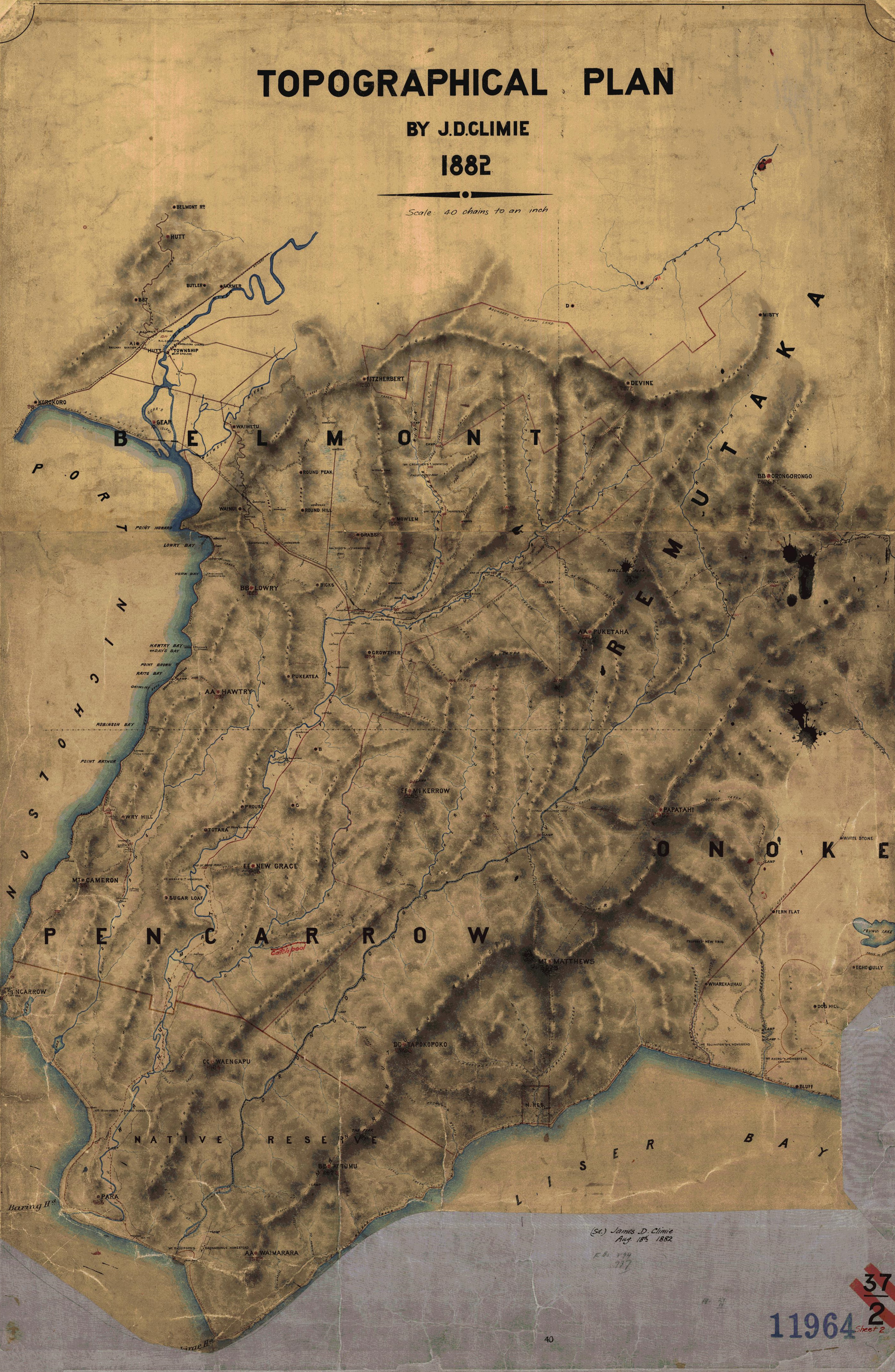
Sketch showing peaks, ridges, rivers, and other features of Wainuiomata in 1882.
This 1882 map shows the topography of the land in Wainuiomata, outlining buildings, tracks, peaks, ridges, and rivers. Notable details include:
- Settler names: Rivers, tracks, and buildings are associated with early families such as Sinclair, Wood, Mowlem, Crowther, Dicks, Prouse, Grace, and Riddiford.
- Buildings: Several homesteads and cottages are marked.
- Native reserve: A large section of land is set aside as a reserve.
- Peaks: Named high points include Wainui, Round Hill, Round Peak, Grassy, Fitzherbert, McKerrow, Pukeatea, Puketaha, Crowther, Mowlem, Sinclair, Hawtry, New Grace, Sugar Loaf, Waengapu, Para, Waimarara, Tapokopoko, and Devine.
- Burned ranges: Some ranges are noted as burned, possibly from controlled burn-offs to create pasture or from natural fires following the spread of gorse after logging.
- Tracks: Routes include Marchant Track and the original Whakanui Track which is marked but unnamed.
- Rivers and creeks: Marked waterways include the Wainuiomata River, Little Wainuiomata River (now called Wainuiomata Stream), Georges Creek, and Sinclair Creek.
- Tramway: The old logging tramway is mapped, with its terminus at Georges Creek deep in Sinclair Valley, and close to two cottages.
Names and Labels
Left out trig heights, bearings, survey measurements and section numbers. The map is a joined version of SO 11963 (Belmont District/Hutt Valley) and SO 11964 (Pencarrow District), both dating from 1882.
(NZ Pictures)
Map title and information
- Topographical Plan
- By J. D. Climie
- 1882
- Scale 40 chains to an inch
- SO 11963
- SO 11964
Major areas and geographical labels
- Belmont
- Rimutaka
- Pencarrow
- Onoke
- Port Nicholson
- Palliser Bay
- Hutt Valley
- Wainuiomata
- Whiteman’s Valley
- Golder’s Valley
- Native Reserve
Peaks, hills and high points
- Wainui
- Mt Grace
- Richmond
- Mt Cameron
- Hawtry
- Totara
- Sugar Loaf
- Fitzherbert
- Round Peak
- Round Hill
- Grassy
- Mowlem
- Lowry
- Dicks
- Pukeatea
- Puketaha
- Crowther
- Sinclair
- New Grace
- McKerrow
- Waengapu
- Para
- Waimarara
- Tapokopoko
- Devine
- Mt Parks
- Kotumu
- Orongo
- Mt Matthews
- Morris
- Misty
Rivers, streams, creeks and gullies
- Wainuiomata River
- Little Wainuiomata River
- Orongorongo River
- George’s Creek
- Sinclair Creek
- Grace’s Stream
- Swainson’s Creek
- Wainui Creek
- Fern Creek
- Wharekahau Creek
- Gravel Gully
- Government Gully
The Little Wainuiomata River shown on the map is what is now generally called Wainuiomata Stream.
Tracks and routes
- Marchant Track
- Track from Wainuiomata to the Orongorongo River
- Track via Mt Richmond to the Orongorongo River
- Original Whakanui Track route – shown but not named
- Sinclair logging tramway
Climie’s notes describe two tracks from Wainuiomata to the Orongorongo River, including one via Mt Richmond, and record that both were well blazed in 1882.
(NZ Pictures)
Settler and property names
- Sinclair
- Wood / G. Wood
- Mowlem
- Crowther
- Dicks
- Prouse
- Grace
- Riddiford
Buildings and other features
- Riddiford’s Homestead – Wainuiomata
- Riddiford’s Homestead – Orongorongo
- Cottage
- Cottages near George’s Creek
- Mill
- School
- Post Office
- Bridge
- Stockyard
- Camp
- Brown’s Camp
- Camps on the Orongorongo River
- Lighthouse
- Tramway
- Island – Wainuiomata River
- Native Reserve
Climie’s contemporary survey notes specifically record mills, a school, post office, bridges, camps, stockyards, Riddiford’s homesteads and a lighthouse among the features observed during the work that produced these surveys.
(NZ Pictures)
Descriptive landscape labels
- Burned / burnt ranges
- Burnt spur
- Bush
- Edge of timber
- Deep gully
- Sea




