
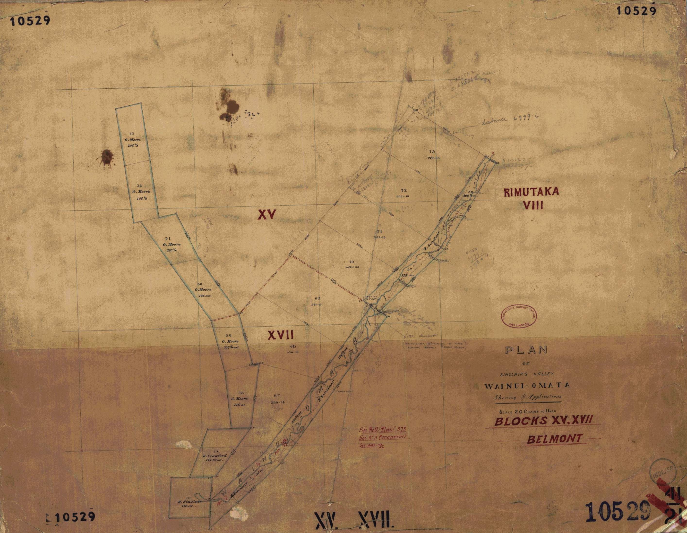
The historic name of the upper Wainuiomata valley before it became known as Waterworks Valley and later Reservoir Valley.
Before it became known as Waterworks Valley and, later, Reservoir Valley, this upper branch of the Wainuiomata Valley was known as Sinclair Valley, after the Sinclair family who owned land and operated a major timber-milling business in the area during the nineteenth century.
Hugh Sinclair acquired land in the upper Wainuiomata catchment during the 1850s, and the family later milled the extensive native forest of Sinclair Valley. His sons, John and Duncan Sinclair, continued the operation and developed a tramway into the valley to transport timber to their sawmill near the junction of Moores Valley and the main Wainuiomata valley. During the 1870s they upgraded the system with iron rails and a small steam locomotive.
The character of the valley began to change in the late 1870s when Wellington City Council investigated the upper Wainuiomata River as a possible source of water for the growing city. In May 1878, council representatives travelled into Sinclair Valley with Duncan Sinclair, using the family’s logging railway for part of the journey.
As construction of Wellington’s Wainuiomata water supply began around 1880, the old name gradually gave way to Waterworks Valley. Much later it became known as Reservoir Valley, the name by which the area is generally known today.
Map title and identification
The main title panel reads:
PLAN
OF
SINCLAIR’S VALLEY
WAINUI-OMATA
Shewing 5 Applications
Scale 20 Chains to 1 Inch
BLOCKS XV, XVII
BELMONT
The Survey Office number 10529 appears several times around the outside of the sheet. A Wellington survey-plan catalogue dates SO 10529 to 1862, which makes this a particularly early use of the name Sinclair’s Valley.
Sinclair’s Valley and Wainuiomata
The most important geographical name is, of course, Sinclair’s Valley, prominently used in the title. The locality beneath it is written WAINUI-OMATA, retaining the nineteenth-century hyphenated spelling.
Across the long narrow valley itself, the letters of WAINUIOMATA are spread along the watercourse and valley floor. The winding line running through this strip represents the upper Wainuiomata River and its tributary channels. This is therefore a useful map for showing exactly what nineteenth-century surveyors meant when referring to Sinclair’s Valley.
Landowners named on the map
There are three clearly readable personal names. H. Sinclair appears on Section 26, which is marked as 116 acres, and Sinclair’s name also appears again within the long narrow strip following the Wainuiomata valley. This is the Sinclair after whom the valley was named.
R. Crawford is shown on Section 27 immediately north of Sinclair’s land. G. Moore is the other major landholder named on the plan, appearing repeatedly on Sections 28, 29, 30, 31, 32 and 33. The Moore holdings form a long sequence of adjoining sections on the western side of the valley.
The map therefore records the names H. Sinclair, R. Crawford and G. Moore.
Section numbers
The earlier land parcels on the western side of the valley are numbered 26, 27, 28, 29, 30, 31, 32 and 33. Within the narrow Wainuiomata valley strip, the section numbering continues through approximately 34 to 39.
A second, much larger pattern of survey sections is superimposed over the country farther east and north. These are Sections 67, 68, 69, 70, 71, 72 and 73. The surviving Survey Office catalogue specifically describes SO 10529 as relating to Wainuiomata Sections 67–73, and also records the plan under the names “Moores Valley & Sinclair Valley”. NZ Pictures
Belmont and Rimutaka
The large red Roman numerals XV and XVII identify the relevant blocks of the Belmont Survey District. This agrees with the title, which reads “Blocks XV, XVII — Belmont”.
On the eastern side of the map is the prominent label RIMUTAKA VIII, identifying Block VIII of the Rimutaka Survey District adjoining the Belmont blocks. Along the lower edge, XV. XVII. is also repeated as a block reference.
Moore’s Valley
There is faint later handwriting near the central part of the map associated with Moore’s Valley. It is difficult to decipher every word from this scan, but the identification of Moore’s Valley is supported by the Survey Office catalogue, which describes the plan as covering “Moores Valley & Sinclair Valley”.
This is interesting because G. Moore’s sections lie immediately west of Sinclair’s Valley, showing why the two valley names occur together in later survey references.
Survey Office labels and stamps
The oval official stamp reads “PROVINCIAL SURVEY OFFICE — WELLINGTON”. There is also a circular “INDEXED” stamp near the lower-right corner.
A red handwritten cross-reference near the bottom begins “See Roll Plan 37…”. There are two further lines beneath it, but the final numbers and wording are not clear enough in this copy for me to transcribe them confidently.
Several later pencil annotations give survey measurements. One of the clearest reads “distance 6999.6″. Numerous smaller figures along boundaries are bearings, distances and acreage measurements rather than place or personal names, so I have not treated every one of those numerical survey figures as a separate name or label.
Streams named after Sinclair properties
An especially interesting feature of the map is the naming of several small waterways in the upper reaches of Sinclair Valley. Five names can be identified: Moness Stream, Glenhill Gully, George Wood Stream, Sinclair’s Stream, and Junction Stream.
Three of these appear to match the names of Sinclair family homes. Moness Stream corresponds with the house known as Moness, Glenhill Gully with Glenhill House, and Sinclair’s Stream with Sinclair House. This suggests the Sinclair family’s presence in the valley was reflected not only in the name “Sinclair’s Valley”, but also in the names given to individual streams and gullies.
These waterways lie well upstream of the site of today’s Morton Dam, in the upper reaches of the old Sinclair Valley.




